The Disaster Services Team's 2020 Lessons Learned

What did we learn from the disaster activations of 2020? We explore that question in the context of five of the largest disaster activations of 2020 in this new graphic, and we share ways you can take part in disaster mapping efforts.
To see the full, scrollable version of this article, click here.
CALL TO ACTION
Maps are critical in the hours, days, and weeks after a disaster to help the right people and the right supplies get to the right place at the right time, increasing the potential to save lives. In 2020, HOT led the coordination of five mapping responses to disastrous events - also known as Activations - and played a supporting role in another four responses occurring around the world, all amid a global pandemic.
Would you like to contribute to HOT’s humanitarian mission? Besides mapping on the Tasking Manager, you can spread the word directly with friends and family and by tagging @HOTOSM on your Social Media. Additionally, if you are an experienced OpenStreetMap contributor, you can become a validator and help us ensure high-quality data is delivered to responders and aid agencies. Sign up on our validator application page! Last, if you’re over-the-top dedicated like we are and want to be a part of the Disaster Services Team (DST), you can start by attending the Activation Working Group’s meetings. Ask how in our #disaster-mapping Slack channel.
 Ramani Huria community-based mappers in Tanzania.
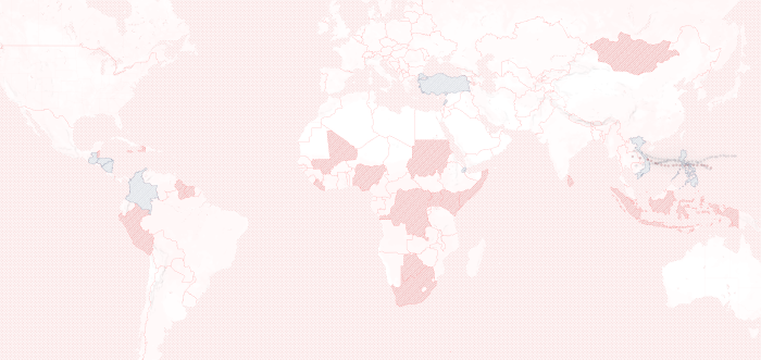
9 ACTIVATIONS IN 2020
MAR. 2019 - NOV. 2020 - Venezuela 195 contributors mapped 434,000 features in OSM- #AyudaVenezuela, More Info
DEC. 2019 - JAN. 2020 - Djibouti Flooding 250+ contributors mapped nearly 150,000 features - #Djibouti_Floods_2019, More Info
MAR. 2020 - ONGOING - Global COVID-19 22,300+ contributors mapped over 4.5 million features so far - #covid19, More Info
MAY 2020 - SEPT. 2020 - West Bengal Cyclone Amphan 1,000+ contributors mapped 311,000 features - #CycloneAmphan, More Info
AUG. 2020 - SEPT 2020 - Beirut Port Explosion 225 contributors mapped 71,000+ features - #BeirutPortExplosion, More Info
OCT. 2020 - ONGOING - Izmir, Turkey Earthquake 690+ contributors mapped 264,500 features - #izmirdepremi, More Info
OCT. 2020 - ONGOING - Philippines & Vietnam Cyclone Molave 950contributors mapped nearly 150,000 features - #CycloneMolave, More Info
NOV. 2020 - ONGOING - Philippines Typhoons: Rolly & Ulysses 2350 contributors mapped 200,000+ features - #RollyPH, More Info
NOV. 2020 - ONGOING - Central America Hurricanes: Eta & Iota 1000+ contributors mapped 150,000 features - #HurricaneEta, More Info
ASIA CYCLONES & TYPHOONS

In the Asia storm responses, local communities took the lead, becoming ‘front-liners in their respective regions.’ However, HOT discovered how it could help prevent attrition in smaller organizations and communities by enhancing and better articulating the -already strong- coordination between, and with, local partners and more effectively identifying priority areas for the Disaster Services Team to support.
The first Tropical Storm of the North Indian Ocean Cyclone Season became Super Cyclonic Storm Amphan. The community in India managed this response with support from HOT for mapper and validator recruitment and documentation assistance.
After that, Typhoon Molave landed in the Philippines in late October. Fortunately, the local community was actively mapping the area struck before the storm hit. Typhoon Molave quickly restrengthened and continued its course to Viet Nam, where HOT Indonesia had been working on the road network and the local community was starting to get organized. The Disaster Services Team worked with local communities and the United Nations Development Program (UNDP) to identify the hardest-hit areas.
In the meantime, the Philippines was the target of two more tropical storms - locally named Rolly and Ulysses. While things were busy globally, the HOT office in the Philippines and our global Disaster Services staff supported these responses with the promotion of projects and documentation. Special thanks to Mapbeks (https://www.mapbeks.org/) and the local OSM Philippines group for the excellent management of these incidents.
 Poster for one of the mapathon and trainings led by Mapbeks and HOT.
CENTRAL AMERICA HURRICANES

Reviewing the responses in Central America had a direct impact on the Disaster Services Team, triggering a review of how global partnerships are handled. It inspired an urgency to find a volunteer to support the Disaster Services Team and the Activation Working Group. To strengthen relationships with responding partners. Ultimately creating more efficient communication in and out of activations.
The first of two storms to strike Central America made landfall in Nicaragua. Hurricane Eta caused storm surges and flooding along the coast, as well as significant rain events to neighboring countries - Honduras, Guatemala, Panama, and Colombia. Hurricane Iota, the last recorded Category 5 storm in the Atlantic Hurricane season, also targeted the Nicaragua coast just two weeks and 15 miles (9.3 kilometers) apart.
Although we were able to connect with local communities, they were unable to manage the request received from Copernicus and HOT led the response in Nicaragua and Honduras.
 A map of Ulua Basin in Honduras to estimate floodings for hurricane Iota that incorporates OSM data. COPERNICUS, European Union Emergency Management Service. (EMSR482)
AEGEAN SEA EARTHQUAKE

Because the earthquake centered in the Aegean Sea did not turn out into a major crisis, minor disruption allowed for a swift response by the local community. Stronger partnerships with local governments and actors would have been useful as the government’s damage assessment was not accessible to actors in the field. However, the great work led by Yer Çizenler helped them strengthen their reputation and secured them a project with the municipality of Istanbul.
A 7.0 earthquake shook the Aegean Sea, causing major damage in Izmir, Turkey. The local community was quick to respond and our partner in the region, Yer Çizenler, jumped into action focusing on field damage assessment mapping partnering with local actors. Access their report in these links Eng / Tur.
HOT’s supported Yer Çizenler with global mapper and validator recruiting, augmenting their capacity to lead the response.
 Yer Cizenler’s map showing buildings that collapsed completely or partially due to the earthquake.
BEIRUT EXPLOSION

During the After Action Review of the Beirut Explosion response, new opportunities for extended collaboration between the local community and other partners were identified. Visit https://openmaplebanon.org/ to learn more about the local community’s efforts and what they plan to map next.
A large amount of ammonium nitrate stored for years at the Beirut Port (Lebanon), exploded on August 4, 2020. The blast caused serious damage to the downtown area, and reports of damage came in from as far as 24km away from the epicenter.
At that time, the downtown area was well mapped by locals. HOT led the mapping projects of an extended area beyond the city center to assist planning and service delivery by the Lebanese Red Cross.
Other Collaborative Initiatives:
Ushahidi - Beirut Explosion is a platform designed for collecting needs and connecting resources.
Mapillary is being used to collect ‘street-view’ imagery of the damage, in turn used by agencies and organizations to estimate the damage and coordinate relief efforts.
 Map on Tasking manager showing tasks for the Beirut Explosion activation.
COVID-19 RESPONSE
In March 2020, the Disaster Services Team Activated to provide geospatial data, maps, and training to identified countries in need. Still ongoing, HOT’s global response to COVID-19 is the largest response ever undertaken by the organization. This response’s gaps and needs have led to an unprecedented level of internal coordination between HOT’s different teams and external collaboration with communities, organizations, agencies, and governments.
As of January 12, 2021, the COVID-19 activation has resulted in over 22,300 mapping contributors adding 4.5 million map features to OpenStreetMap, including more than 4 million buildings and over 97,000 kilometers of road. This response has supported 33 local groups, organizations, and in one case, an individual mapper looking to improve awareness of services in their city. Between remote mapping projects, microgrants, local community efforts, training, and other projects HOT is supporting, there are a total of 28 countries impacted by these COVID-19 prevention, response, and relief efforts. We are also evaluating 11 additional countries in the Caribbean as part of a joint hurricane and pandemic preparedness campaign.

![]()
![]() Map of Liberian county showing healthcare facilities. Photo Credit: iLab Liberia.
Map of Liberian county showing healthcare facilities. Photo Credit: iLab Liberia.
KEY TAKEAWAYS
2020 has been a disruptive year, but HOT has adapted by creating a permanently-staffed global Disaster Services Team (DST). With it has come the opportunity for deeper analysis of how HOT responds - or activates - to emergencies:
Historically, it has been difficult to quantify the impact of responses, and 2020 has not been an exception. To tackle this challenge, the DST will ensure there is a timely After Action Review for every activation. Capturing feedback from all stakeholders and turning them into actionable improvements to our response workflow.
Compliance with the OpenStreetMap Foundation’s Organized Editing Guidelines (OEG) has been a challenge. Whether these are viewed as required or not, adherence may help avoid misunderstandings between groups/organizations and local communities.
Finally, where before it was rare to find a country or even region that had an OSM community, now it is becoming rare to find a country or region without one. It was great to observe many OSM communities growing, becoming self-sufficient, and coordinating disaster responses locally. This has allowed HOT to change its role, from leading activations to supporting communities in their responses.
 Planning for field mapping. Photo Credit: HOT Uganda.