Carpinelo Needs Your Solidarity: Open Mapping Data Available for Emergency Response
Posted by Leonardo Jiménez • May 4, 2026
What happened?
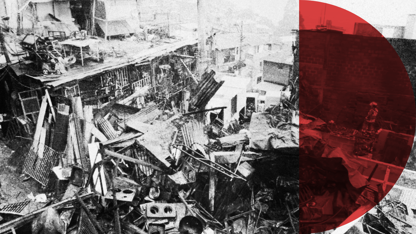
On the night of Sunday, April 26, 2026, a large-scale structural fire broke out in the Carpinelo neighborhood, Comuna 1 (Popular), in the northeastern part of Medellín. The emergency was reported at around 9:20 p.m. near the intersection of Carrera 24C and Calle 95, and required the response of four crews from the Official Fire Department, along with support from DAGRD (the Administrative Department for Disaster Risk Management) and the Social Commission of the Mayor's Office of Medellín.
According to official reports, the fire affected at least 16 structures, including 11 homes and 5 commercial premises. As a precautionary measure, the temporary evacuation of 10 additional nearby homes was recommended. Fortunately, no injuries were reported, but the material losses are significant: many of the affected buildings were wooden structures, and several were used to store recyclable materials, which accelerated the rapid spread of the flames. The arrival of firefighters at the scene was initially hampered by illegally parked vehicles blocking access routes.
Authorities are investigating the cause of the incident. Preliminary evidence suggests the fire may have originated in a home where scrap metal work was being carried out.
Why does open mapping matter in this emergency?
The Carpinelo neighborhood is located in one of Medellín's most vulnerable hillside areas, with slopes exceeding 40%, self-built construction, and socioeconomic conditions marked by deep inequality. These territories,historically invisible on institutional maps, are precisely those that most need quality geographic data for prevention, emergency response, and recovery planning.
Since 2023, the Hillside Territory Mapping School, an initiative led by the POMOTE Studies Center at the Universidad Autónoma Latinoamericana (UNAULA) in partnership with the Humanitarian OpenStreetMap Team's Open Mapping Hub for Latin America and the Caribbean (HOT), has been building a collaborative ecosystem among community, academia, and institutions, focused on producing open data for disaster risk management and climate resilience in Medellín's hillside neighborhoods.
As part of this process, a public map of the Carpinelo neighborhood has been developed, containing georeferenced data on housing, community infrastructure, access routes, and territorial conditions, produced participatorily with community leaders and volunteer mappers. The map is freely and openly available.
A call to use the data to support the community
We call on public authorities, humanitarian organizations, cooperation agencies, and community groups to consult and use the open data produced by the Hillside Territory Mapping School to strengthen support for the families affected by this fire. This data can be highly valuable for:
- Identifying and geolocating affected homes and businesses within the neighborhood's urban fabric, enabling better targeting of humanitarian aid.
- Planning access and evacuation routes, taking into account the territory's topographic complexity and the access difficulties already evident during the emergency.
- Carrying out a census of those affected and characterizing families with detailed cartographic support that complements institutional tools.
- Assessing risk conditions in neighboring buildings and prioritizing reinforcement or relocation interventions.
- Designing prevention and early warning strategies grounded in communities' territorial knowledge and open geospatial information.
Open data, resilient communities
This fire reminds us, once again, that Medellín's hillside territories face recurring threats: structural fires, landslides, overflowing streams, and the effects of climate change. The response cannot be limited to emergency relief, what is needed is a sustained strategy of prevention and preparedness that integrates community knowledge with available technological tools.
The Hillside Territory Mapping School has demonstrated that communities can be the protagonists in producing data about their own territory. Participatory mapping not only generates quality geospatial information; it also strengthens the social fabric, empowers community leaders, and creates channels of dialogue between communities, academia, and institutions.
We invite all stakeholders to make use of this public data and to join the community mapping efforts underway across the city.
Read the original post (in Spanish): Carpinelo Necesita tu Solidaridad: Datos de Mapeo Disponibles
Share
