Mapping Limonade: How Sonje Ayiti is Putting Communities at the Center of Disaster Preparedness
Posted by Louise Mathurin Serieux • May 21, 2026
In 2025, when floodwaters threatened Limonade, Haiti, local mappers were already ahead of the crisis. As part of the HOT Caribbean Collective Microgrant Programme, the Sonje Ayiti Organization (SAO) had spent weeks on the ground with trained community agents, mapping 68 schools and four high-risk zones to strengthen flood preparedness. The work paid off: municipal authorities received actionable geospatial data and committed to installing physical safety signage in the most vulnerable areas.

But this kind of impact doesn't happen overnight, and it doesn't happen alone.
Behind this achievement is more than a decade and a half of Sonje Ayiti's deep roots in northern Haiti. For over 18 years, this local non-profit has implemented community-designed programs across education, economic development, and health promotion. When the Humanitarian OpenStreetMap Team (HOT) formalized a partnership with SAO through an MOU in 2024, it was a meeting of two organizations that share the same conviction: that communities themselves hold the knowledge needed to protect their people. Together with local youth groups, OSM community members, and university students from Limonade, they have since carried out open mapping trainings and a city-wide litter-mapping and cleanup campaign in collaboration with Young Power.
In the face of increasing environmental hazards, data is the first line of defense. As part of the HOT Caribbean Collective Microgrant Program 2025, SAO completed a critical mapping project in the municipality of Limonade. By leveraging open-source geospatial tools, SAO is helping the community transition from reactive disaster response to proactive risk management.
The project aimed to provide local authorities, including Civil Protection and the District Education Office, with a reliable database to protect Limonade's most vulnerable citizens. Over a concentrated field mission in November 2025, a trained team of local agents hit the ground to identify and geolocate high-priority sites.
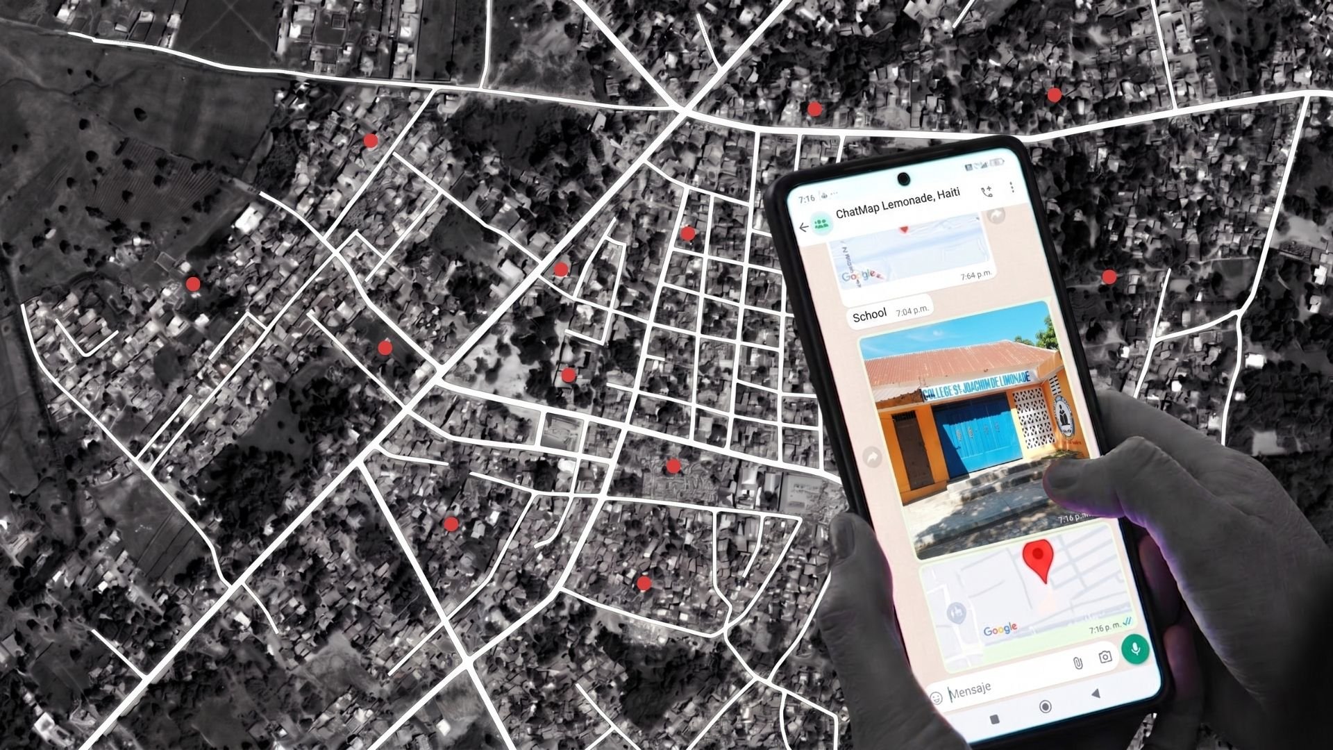
The field team successfully captured four high-risk zones: the Bank of Bois de Lance River, Limonade Seafront, Basse Salines, and Ravine Pistere. They also used HOT's latest tool, ChatMap, to map 68 schools, allowing for the creation of specific school emergency plans and ensuring children can be protected or evacuated quickly during a disaster.
This isn't just about dots on a map; it's about community involvement in identifying the matters that specifically compromise the safety of persons. By integrating this data into OpenStreetMap (OSM), the project ensures that first responders and displaced persons navigating unfamiliar territories know exactly where the danger zones are. City officials can prioritize infrastructure repairs and prevention; educational authorities can better coordinate with emergency services to safeguard students.
Looking Ahead

Founder & Executive Director of Sonje Ayiti, Gabrielle Aurel, highlighted that:
Through this HOT Partnership, 23 SAO mappers are now equipped with the tools to provide Sonje Ayiti with crucial and valuable information for sound decision-making, planning, and communication to visualize, understand, and navigate complex data that were not available to us before teaming with HOT. We capitalize on those skills to pay forward by helping the Ministry of Education to identify all the schools in the Limonade district and the hazardous sites for Civil Protection to curtail unforeseen disasters. Sonje Ayiti Organization can now easily and visually represent our community characteristics and resources within. SAO plans to enhance more mappers to map Haiti.
The team officially presented its mapping work at the Limonade District Education Office (BDS) on January 27, 2026, in the presence of inspectors from the education office, Civil Protection officials, and representatives from Limonade Town Hall.
Since then, the Limonade Mayor's office and Civil Protection have already agreed to partner with the SAO team to install physical signage in the four identified risk areas, and in additional ones that Civil Protection plans to map alongside SAO for better coverage. This ensures that the digital data translates into real-world awareness and safety for everyone in the community. Following the presentation, the head of Civil Protection emphasized the crucial importance of these tools for public safety, while noting that the current work needs to expand, as too few risk areas are currently identified on the existing map.
As a recommendation and to address this pressing need, the Civil Protection agency expressed the wish to train their own agents in geospatial data collection tools and collaborate on an intensive field mission in the future. In response, the Sonje Ayiti organization plans to hold an intensive mapping in conjunction with the Limonade Civil Protection. This activity will aim to comprehensively map the vulnerable areas of the municipality.
Share
