Mapping Through the Storm: How Dominica's Office of Disaster Management Responded to the April 2026 Trough System
Posted by Anique Joseph, Arnelle Isaac • June 13, 2026
The Commonwealth of Dominica, a Small Island Developing State in the Eastern Caribbean, ranks among the most hazard-exposed nations in the region. Its mountainous terrain, dense river networks, and extensive coastline make it highly vulnerable to tropical storms, flooding, landslides, and seismic and volcanic events. In response to this reality, the Government of Dominica has made disaster risk reduction and climate resilience central to national development, as reflected in its Climate Resilience and Recovery Plan.
The Office of Disaster Management (ODM), operating under the Ministry of National Security and Legal Affairs, serves as the lead government agency responsible for coordinating disaster preparedness, response, and recovery across Dominica. The ODM collaborates closely with community volunteer emergency response teams, line ministries, and international partners to strengthen disaster risk governance at all levels.
On April 26th, 2026, a trough system made impact on the Commonwealth of Dominica, bringing sustained heavy rainfall that triggered widespread flooding, landslides, and significant infrastructure damage, particularly across the eastern part of the island. Road networks were affected and some areas rendered impassable, isolating communities and disrupting access to essential services. One major bridge was affected and the cutting of some communities in that area. Both residential and commercial structures were affected, some damaged, some sustained structural damage, and while others were compromised by landslides which resulted in risk to life and property, compounding the humanitarian challenges faced by affected communities.
The Office of Disaster Management through the National Emergency Planning Organization activated its emergency protocols and conducted rapid damage and need assessments across affected areas. Relief supplies were mobilized and distributed to impacted communities and persons, while consistent communication was maintained with national stakeholders to ensure the timely flow of information
HOT’s support after the Trough System
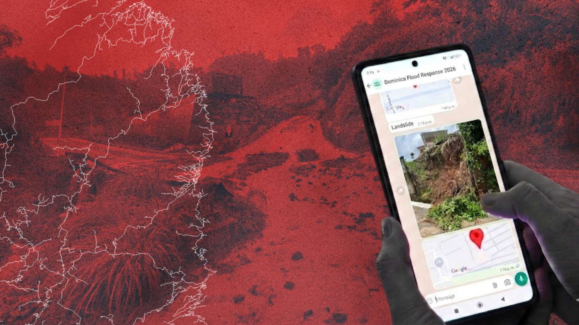
I first learned about ChatMap through a short course on the Humanitarian OpenStreetMap Team (HOT) Tasking Manager, which introduced me to open mapping workflows and practical tools for disaster response. During the April 2026 trough system, ChatMap played a central role in ODM’s operations by enabling staff to capture and share field assessment information, visualize flooding and landslide impacts, and communicate situational updates.
ChatMap was particularly useful for:
- Providing a simple, accessible platform for ODM officers and field teams to report damage in real time, enabling rapid aggregation of information from multiple sources across the affected areas.
- Field teams used ChatMap to log geo-tagged reports of damaged bridges, impassable roads, landslide locations, and affected housing structures, giving the ODM a consolidated and spatially accurate picture of the event’s impact.
- ChatMap’s data was used to communicate impact to government stakeholders, including the Ministry of National Security and Legal Affairs and shared with regional and international partners such as the Caribbean Disaster Emergency Management Agency (CDEMA) and the Geotechnical Assessment Team.
In addition to ChatMap, ODM also used OpenStreetMap (OSM), QGIS and uMap for data export, analysis, and archiving, which complemented ChatMap’s rapid communication features. HOT’s support extended beyond the tool itself, technical guidance during the response, strengthening ODM’s ability to integrate open mapping into disaster management.
Looking forward
The April 2026 trough system response demonstrated the value of integrating open geospatial tools into Dominica’s disaster management workflows. Building on this experience, the ODM looks forward to deepening its partnership with HOT in the following ways:
- Capacity Building: Expanded training for ODM staff and community emergency response teams on the use of ChatMap and OSM-based tools, ensuring greater institutional readiness ahead of the Atlantic hurricane season.
- Pre-positioning of Data: Collaborative mapping exercises to improve baseline OpenStreetMap data for Dominica’s road networks, bridges, and community infrastructure, enabling faster and more accurate damage assessments in future events.
- Integration into Standard Operating Procedures: Support from HOT in formally integrating Chat Map into the ODM’s emergency response protocols and standard operating procedures.
- Community Mapping: Engagement with local communities and volunteers to build a network of local mappers who can contribute to real-time reporting during disasters.
- Ongoing Technical Support: A sustained relationship with HOT to provide technical assistance, tool updates, and remote mapping activation support during future disaster events affecting Dominica.
Dominica’s ODM values its partnership with HOT as a critical component of its broader strategy to build a climate-resilient and disaster-ready nation. The ODM looks forward to a long-term, collaborative relationship that harnesses the power of open data and community mapping to protect Dominican lives and livelihoods.
Share
