



The Night Venezuela Shook: How Open Mapping Data Made the Emergency Response Faster
Posted by Mar Marín Villagrana, Camila Garzon-Ruiz, Jessica Pechmann, Céline Jacquin, Sam Colchester, Arnelle Isaac, Kshitij Sharma • July 9, 2026
This title draws on the amazing storytelling of Akash Wadhwani's "The night the earth shook, strangers started to draw", which traced how collaborative mapping became a core part of humanitarian response in Haiti, Nepal, Morocco, and now Venezuela. We recommend reading it in full.
On June 24, 2026, two of the strongest earthquakes Venezuela has recorded in over a century struck the country's northern coast, causing severe destruction in La Guaira and Caracas. The toll is painful: 3,535 dead, 16,400 injured*, and tens of thousands are still missing. In an emergency like this, one thing shapes how many people are reached in time: the availability of mapping data that can guide humanitarian aid.
590 hand drawn 97,000 buildings in Caracas and La Guaira
More than 136,000 total edits on OpenStreetMap.
360+ downloads
Published openly on HDX and downloaded 360+ times.
30 volunteers → 24 hours
Volunteers validated fAIr's AI damage predictions via MapSwipe within the first day.
Closing the gap, in hours
Analyzing available data just hours after the earthquake made it clear that the affected areas were missing most building footprints in an open, downloadable format that any organization could use without requesting permission or paying a license for access. Spot checks in several urban centers found only a handful of buildings digitized, usually just a few important public ones, leaving an estimated 90% or more of buildings in these areas unmapped. That's the difference between data sitting on a private server and data a rescue team can carry on their phone, offline, in the middle of a collapse site. This data gap is what determines how fast and efficiently an entire network of humanitarian organizations can move.
That's also why speed doesn't mean mapping everything, everywhere. From the first hour, the priority is understanding what the response actually needs from partners on the ground, and mapping with intention rather than volume. At the Humanitarian OpenStreetMap Team (HOT), this is a focus we revisit constantly, from those first hours through the months of recovery ahead.

The people of Venezuela conduct a search and rescue in La Guaira, Venezuela, June 28, 2026. Credits: Cpl. Daniel Garcia, 24th Marine Expeditionary Unit / U.S. Marine Corps. Source: Wikimedia Commons
Tasking Manager: where the response began
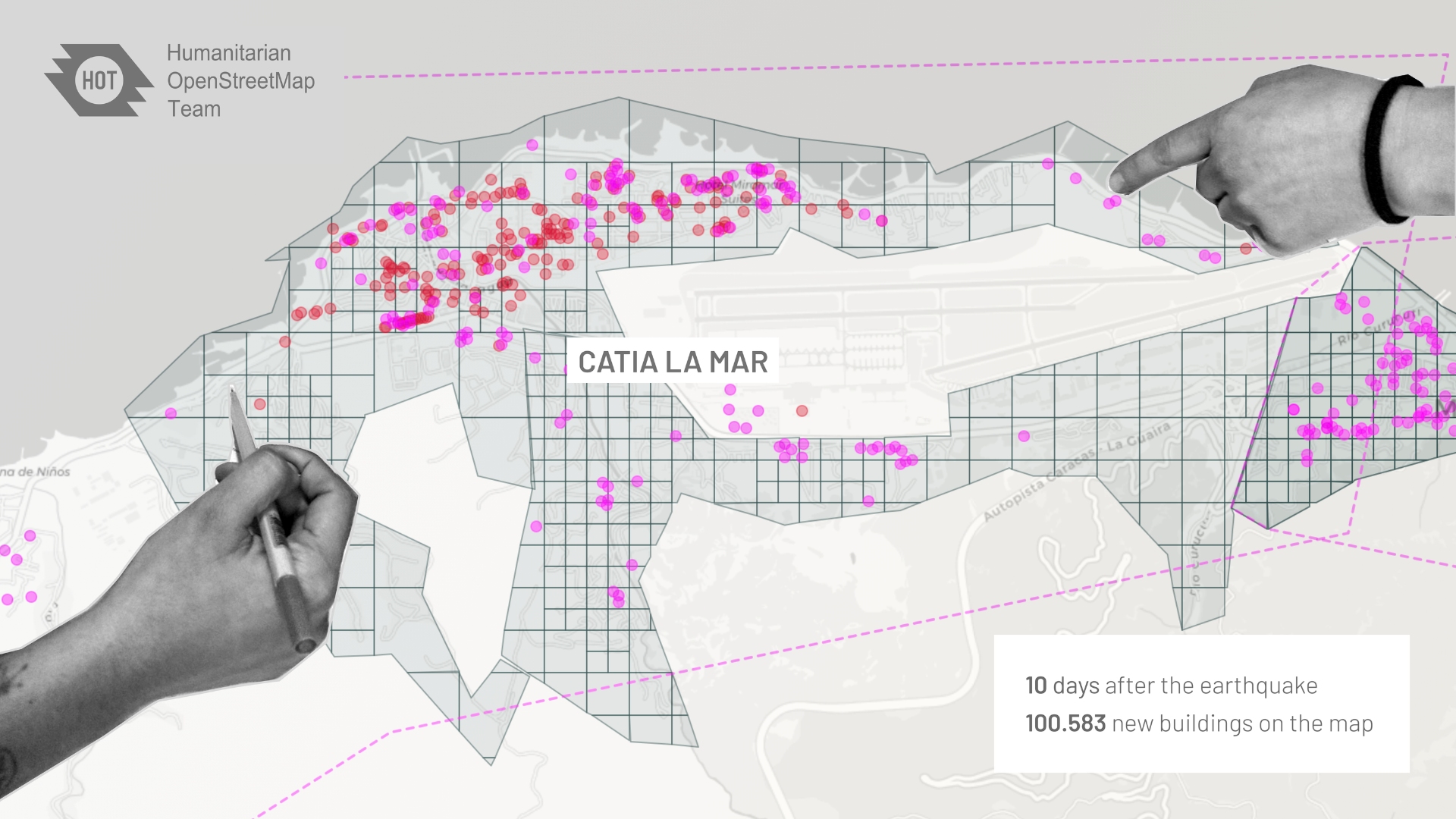
The mapping response started with the Tasking Manager, through collaborative mapping: closely articulated with humanitarian organizations acting on the ground, where they demand data for response, volunteers manually trace buildings from satellite imagery, building by building. Within the first days, that manual effort had already confirmed the areas of greatest priority; within a week, 450 mappers had traced more than 53,000 buildings footprints.
Two weeks into the activation, that number has grown substantially: 590 contributors have mapped close to 97,000 buildings. What makes this number significant is the difficulty of the terrain, almost all projects have had to be restricted to intermediate and advanced mappers, because of the high density of construction in the affected areas and the number of high-rise buildings, which make tracing far more challenging than in a typical mapping and validation activation. You can download the data here.
Petare, Caracas — buildings mapped after the June 24, 2026 earthquake. Sample area 2 × 2 km.
Using AI and human validation
In parallel with the manual mapping efforts, fAIr, HOT's AI-assisted mapping tool, was leveraged to provide additional data on the situation on the ground.
In the hours after the earthquake, very little open data existed for the affected areas. In that gap, two things mattered most: building density, as a proxy for where people were concentrated, and building damage, as a proxy for where communities have been most severely affected.
fAIr isn't a single AI model. It's an open marketplace that connects mappers with existing open geo-AI models they can pick, run, and adapt to their own area, which is what lets it move fast, scale and retrain when humans validate the output. For Venezuela, that meant plugging in different models for following tasks:
- A building density estimate, using pre-disaster imagery at an aggregated level (clusters of buildings), to identify where construction was densest. This helped decide Caracas and La Guaira as priority areas to map first.
- Building-level predictions, generated from pre-disaster imagery, refining that first estimate down to individual structures.
- A damage assessment model, embedded into fAIr the same day as the earthquake, predicted different levels of damage by comparing pre-and post-disaster imagery.
- Instant validation by global volunteers via MapSwipe, humanly validating the results of the AI.
Download AI-validated damage assessment area data
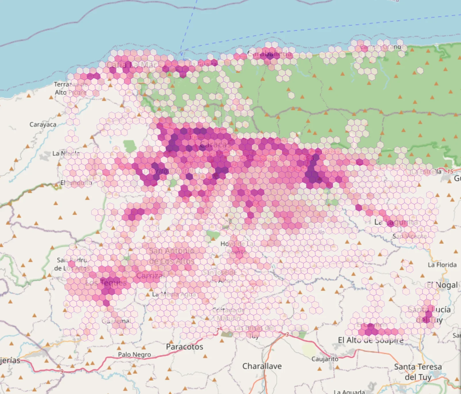
Building density estimate for Caracas and La Guaira, generated by fAIr using pre-disaster imagery at a cluster scale to help prioritize mapping areas.
HOT places people at the center of its designs, tools, and programs. With AI, that means asking whether it is actually useful to apply AI, keeping human validation in the loop while doing so, and ensuring representation in how it's applied.
That's why every one of these AI data layers is treated as preliminary until it passes through human hands. No AI prediction is treated as reliable data until a global community of global volunteers has reviewed it.
That validation happens through MapSwipe, a crowdsourced aerial imagery analysis app. More than 600 volunteers contribute continuously to validating the AI's damage assessment.
It's not only fAIr's outputs being validated this way, results from several different damage-assessment models are combined and cross-checked to optimize accuracy of the output.
That step is what turns a prediction into data a response team can plan around. It is also what sets HOT apart: keeping a human in the loop at this stage is core to how we approach AI-assisted mapping.
Once the data is validated, it's shared through two data-sharing partnerships: the International Charter 'Space and Major Disasters', Techo Venezuela, and United Nations Office for the Coordination of Humanitarian Affairs (UNOCHA)'s Humanitarian Data Exchange. Both give access to their full network of member organizations, extending the data's reach well beyond HOT's direct partners on the ground.
ChatMap: the alert and confirmation only someone on the ground can give
Since June 30, community reporting through ChatMap has complemented satellite imagery and AI analysis with something only people on the ground can provide: firsthand information. Through WhatsApp, people inside Venezuela share their location, along with photos and videos of damage, shelters, and emergency encampments, creating a real-time picture of conditions as they unfold.
ChatMap is now live for ground damage assessment of both buildings and roads, and it runs through a deliberately filtered process. Reports come in through a public WhatsApp group open to anyone in an affected community. From there, a brigade of trained volunteers reviews what's shared and validates the information before it's added to the live public map..
On the damage-assessment side, ChatMap reports are cross-checked against post-disaster imagery overlays and aggregated into categories: complete damage, completely destroyed, minimal damage, some damage, building a picture of severity block by block.
ChatMap has also taken on a newer, more urgent task: mapping emerging shelter encampments, or "tent cities," that have formed in open spaces around Caracas and La Guaira. Humanitarian partners on the ground asked for this specifically, so they know where to direct aid. You can read about our data principles and responsible and ethical data framework here.
Field mapping with local knowledge is the key for validating AI and other remote-sensing data, while producing high-value data that’s not possible to get using satellites and drones alone. ChatMap is the most accessible way to do it — Emilio Mariscal, Software Engineering Manager.
Check out the current ChatMap products!
What open, timely data makes possible
The HOT mapping tools and the speed of the emergency data response can change real decisions on the ground. The first essential approach is to assess and respond to the needs of responders, then to develop rapid and pertinent mapping actions. The data created with that focus was published openly on the Humanitarian Data Exchange and has already been downloaded more than 360 times since the earthquake, by multiple organizations. The International Organization for Migration (IOM) and MapAction have already used it to inform logistics for the delivery of food assistance by air just 9 hours after the earthquake.
Open map data is the foundation for disaster response. Data that is available to everyone, at every stage of the response. The same open map guiding search and rescue becomes the base for assessing damage, planning recovery, and rebuilding. No one starts from zero. Crucially, communities on the ground are part of the process, making the data reliable and useful beyond the emergency. Our activation supports Venezuela not only in the first weeks but in the long run, as the country and its people rebuild. — Fabrizio Scrollini, Programs Senior Director and LAC Regional Director.
This mapping activation doesn't end after the first 24 or 48 hours. Needs keep being assessed, methods get adjusted, models get refined, and predictions get validated. Priority areas keep shifting, adapting quickly to the changing needs on the ground.
The more hands that take part: tracing, validating, or sharing what they see from inside Venezuela, the faster and more accurate the data becomes: building footprints, on-the-ground reports, and damage assessments alike. That's what keeps organizations equipped for both the emergency response and the recovery ahead.
If you're outside Venezuela, a twenty-minute tutorial is all it takes to trace your first building on the Tasking Manager. If you would rather contribute to this mapping effort from your phone, MapSwipe takes about five minutes to learn. And if you are inside Venezuela and are a member of communities affected by the earthquake, ChatMap remains open on WhatsApp to share a location along with photos or videos of damage and shelters.
Are you a humanitarian responder on the ground with a specific data need?
Contact us!How you can support the response!
Share




