Peer-to-Peer Drone Mapping & Digitization in Waterloo, Sierra Leone
Learn and Connect • Waterloo, Sierra Leone • Community-Led
The Freetown Open Drone Crew is sharing their skills with residents in Waterloo to help them collect their own city-wide imagery using low-cost drones. By combining aerial imagery, community collaboration, and open source tools, they're working together to strengthen disaster preparedness, improve urban planning, and ultimately build more resilient communities.
Mapping a Growing City's Needs
As a rapidly growing city, Waterloo, Sierra Leone, has emerged as a vital residential hub for commuters to the capital for work or business. Its strategic location serves as a gateway to the provinces, effectively linking Freetown with other regions across the country. However, like most cities in Africa, Waterloo has limited, up-to-date, and comprehensive geospatial data, which is essential to strengthening humanitarian action, development planning, and disaster risk reduction. Institutions such as the Office of National Security (ONS), the National Disaster Management Agency (NDMA), and the Japan International Cooperation Agency (JICA) also needed this data on buildings, roads, and infrastructure, particularly in high-risk areas like Hill Court Road. Communities living in flood- and landslide-prone areas were especially vulnerable due to limited information for preparedness and response.
This project addresses these challenges by generating accurate, high-resolution geospatial data through drone mapping and community digitization. This openly accessible data would support evidence-based decision-making for local authorities and partners.
Learning by Doing; Peer-to-Peer Drone Mapping
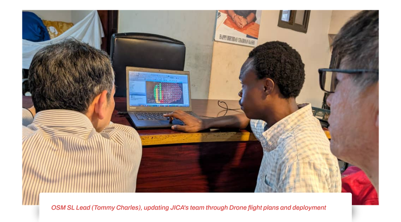
The Waterloo Drone Mapping Project follows a peer-to-peer, use-case-driven approach that centres local institutions and open tools. The methodology was co-designed with the Japanese International Cooperation Agency (JICA), the Office of National Security (ONS), the National Disaster Management Agency (NDMA), and the Waterloo City Council, to align mapping priorities with actual organizational needs.
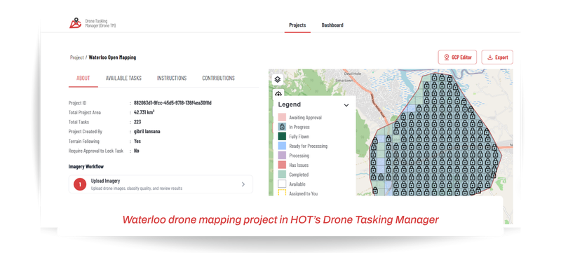
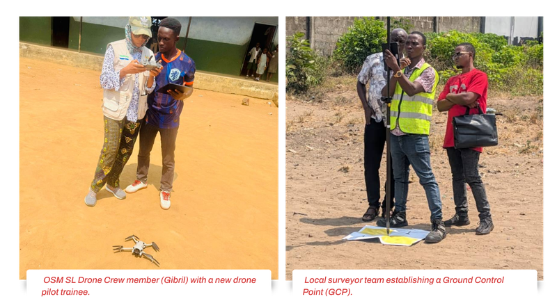
A core part of this project is peer-to-peer learning. The Freetown Open Drone Crew travelled to Waterloo to teach representatives from these institutions how to fly drones, pairing experienced pilots with new pilots to support them during field exercises. plan flights with DroneTM, collect high-resolution aerial imagery, and process it into usable geospatial products. Participants learnt how to use a plethora of open-source tools, including HOT’s Drone Tasking Manager and Tasking Manager, to digitise their city
This peer-to-peer approach is sustainable and scalable. With access to drones housed at Freetown City Council, national and local stakeholders can now independently replicate the methodology, integrate it into their programmes, and expand coverage to new neighbourhoods and hazards. The resulting open, high-resolution drone imagery is hosted on Open Aerial Map, and the derived geospatial data is available on OpenStreetMap (OSM), which organizations can use for planning and response.
Impact Beyond the Numbers
Over 64,581 images were collected and processed into 3-centimeter high-resolution aerial imagery, resulting in 5,162 buildings mapped, surpassing the target of 1,000. 24 people were trained, including 4 women, equipping local stakeholders with skills in drone mapping and image processing.
JICA intends to use the tools for the disaster preparedness project, NDMA will use the tools for planning, strategizing, and building stronger resilience and response efforts, Waterloo authorities plan to use the data to promote urban planning, revenue generation, and service delivery, while the ONS will use the tools to improve security, patrols, and effective surveillance for the public good.
It was truly inspiring to see the scale of open mapping in Sierra Leone — especially how the work was mobilized on the ground with OSM Sierra Leone and national stakeholders. It really showed what is possible when collaboration works well at scale. I sincerely hope JICA can continue to engage in open mapping efforts like this going forward. Fujimura Hidenori – Senior Advisor on Geospatial Information, JICA
We sincerely value your collaborative efforts and teamwork, which demonstrate that the young people of Sierra Leone are indeed drivers of change, contributing to national progress.It was a pleasure working with … [Freetown] team, young professionals such as yourselves make a meaningful impact. Your leadership and determination will benefit our institutions as we apply these skills going forward. Ms Bilkisu Jalloh - Stakeholder, Drone trainee
What's Next?
The project demonstrated that combining drone technology with community engagement is highly effective in data-scarce environments. Strong collaboration with local institutions ensured the data's relevance and ownership.
However, continued efforts are needed to maintain and update datasets over time. Future steps include scaling the approach to other high-risk areas in Sierra Leone and providing ongoing technical support to trained stakeholders to ensure sustained impact.
