How ChatMap Turned WhatsApp Messages into Emergency Maps During Hurricane Melissa in Jamaica
Publié par Arnelle Isaac • 6 mai 2026
Imagine a tool that utilizes your preferred communication platforms to generate critical data for emergency response. This is what HOT's ChatMap is designed to do.
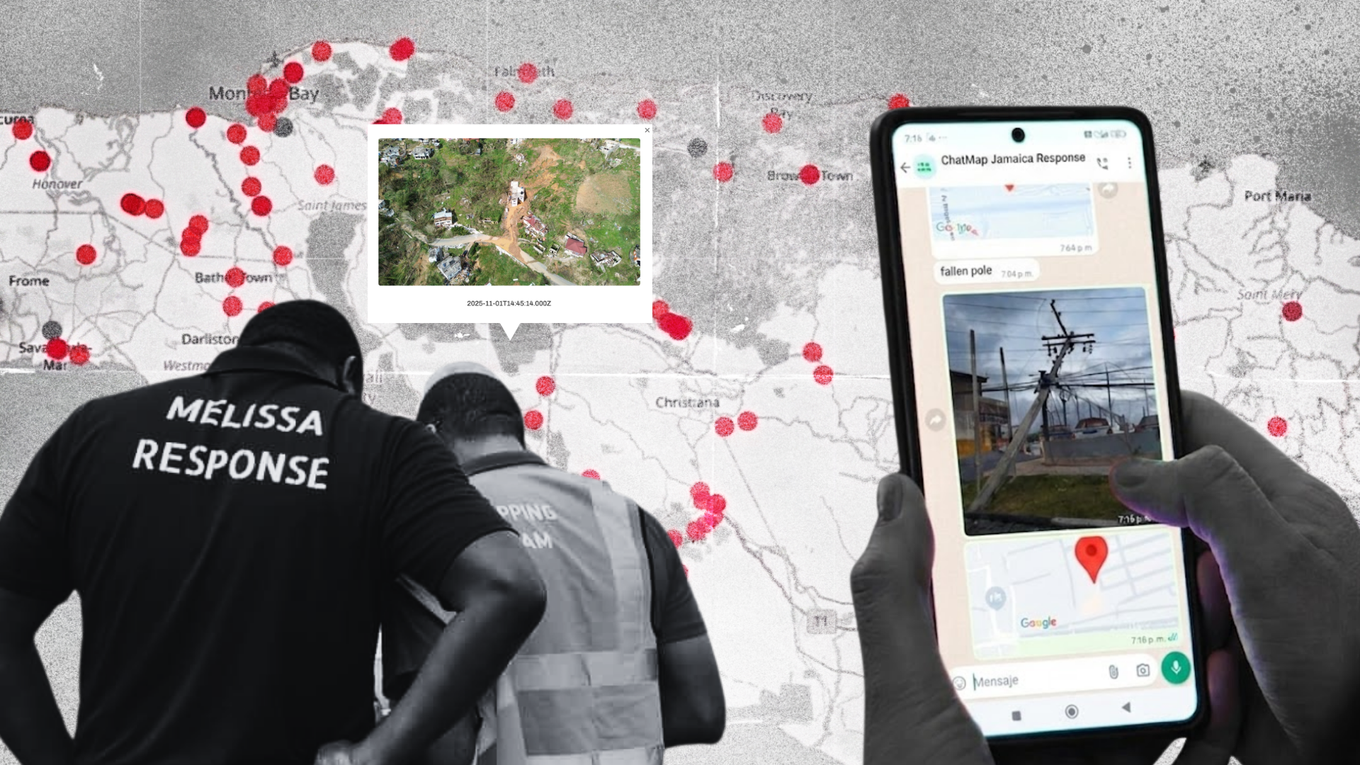
ChatMap is a low-barrier innovative tool that geolocates messages, photos, and videos from chats in communication apps such as WhatsApp, Telegram, and Signal. The tool, within seconds, automatically creates data-rich maps from a simple three step process. As one of HOT's newest innovations, ChatMap played a significant role in our response activities to Hurricane Melissa in Jamaica.
Our Immediate Response
Prior to and in the hours immediately after Melissa's landfall, HOT activated disaster response protocols in close coordination with Office of Disaster Preparedness and Emergency Management (ODPEM), the Caribbean Disaster Emergency Management Agency (CDEMA), MapAction, and local partners like Jamaica Flying Labs and UWI Mona’s Caribbean School of Data (CSoD).
The first action was deploying ChatMap. Prior to Melissa's landfall, HOT and our partners in Jamaica were able to create a WhatsApp group that was open to the Jamaican public. Due to extensive sharing via social media platforms, the group was able to meet and maintain maximum capacity of 1,024 members before, during, and weeks after Melissa. To respond to this overwhelming response by the Jamaican people, a second group chat was created.
Despite the challenges of downed infrastructure, individuals contributed critical ground intelligence with 3,500+ participating in the two group chats. Residents were invited to share photos, videos, and locations of flooding, road or bridge washouts, landslides, rockfalls, fallen trees, and power lines. This crowdsourced data was verified by our Humanitarian Mapping Brigade to create actionable maps with over 200 data points for Jamaican authorities and responders.
Despite the challenges of downed infrastructure, individuals contributed critical ground intelligence with 3,500+ participating in the two group chats. Residents were invited to share photos, videos, and locations of flooding, road or bridge washouts, landslides, rockfalls, fallen trees, and power lines. This crowdsourced data was verified by our Humanitarian Mapping Brigade to create actionable maps with over 200 data points for Jamaican authorities and responders.
Alicia Edwards, Jamaica's Principal Director at the National Spatial Data Management Branch (NSDMB) testified that her team received 'solid data' that was a great 'value add' and easily incorporated into their national systems that relies heavily on ESRI products.
The existing ChatMap platform provided critical situational awareness and streamlined the way damage to buildings is monitored across Jamaica. The mapping activities are aiding relief efforts by providing necessary base data. ChatMap data integrated into ESRI systems; deemed "invaluable" by NSDMB.
Apart from collecting geotagged data, the WhatsApp groups provided an interesting secondary benefit. The groups provided a space for persons to share their experiences, learn about other affected areas, and support response activities such as search and rescue by sharing time-sensitive information with relevant authorities.
As a testament to the tool's effectiveness and user-friendliness, Jamaica's Spatial Data Unit additionally requested a special instance of ChatMap for the project to have identification of roof damage of a particular location earmarked for immediate attention, demonstrating institutional buy-in and reliance on the mapping capabilities. This was groundbreaking as it is very rare that new data collection tools are so easily integrated into national systems during peak wide-scale disaster response activities.
Local volunteers were also trained in ChatMap and damage mapping. Over ten agencies and departments in Jamaica benefitted from the data including the Joint Information and Operations Center, Jamaica Defence Force, Jamaica Power Service, National Water Commission, NERGIST, and the National Works Agency.
How ChatMap works
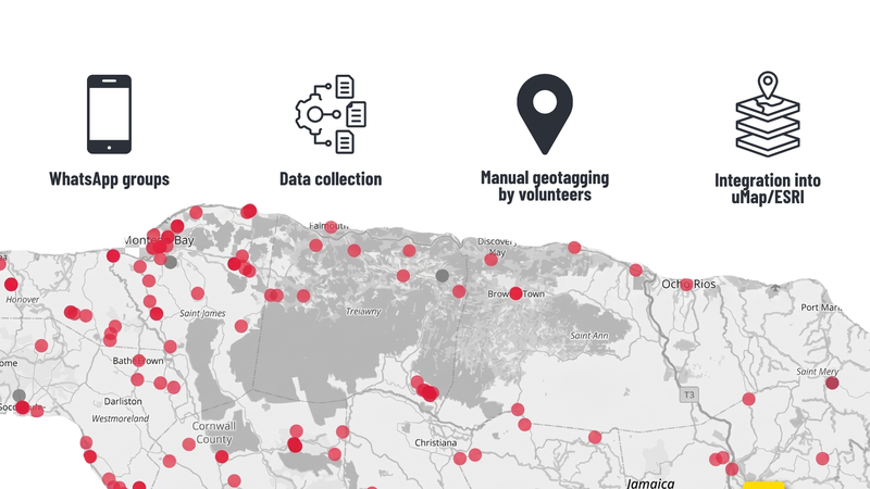
The methodology emphasizes rapid, remote data acquisition and local validation, adapting protocols to optimize volunteer efficiency. WhatsApp/Telegram/Signal users simply send a message, photo, or video of the event they are capturing and then immediately send their current location within the chat. Once all users have sent their media and location information, the chat administrator exports the chat, and uploads the zipped file into the online ChatMap platform. In under one minute, the platform then generates an interactive map with all the data points.
ChatMap Workflow
However, due to the openness of the communication platforms, security concerns must be addressed.
In the case of Hurricane Melissa response, due to the identification of a few scammers attempting to join the community channels, the group activated a setting that requires administrative approval for new members. This measure includes manually verifying every request, including checking the area code, to maintain a safe space.
Following the response: what’s next?
The inaugural use of ChatMap for disaster response of this magnitude presented an opportunity for HOT to closely evaluate the tool and implementation strategies.
The need to implement enhanced administrative approval processes for new members highlights the importance of maintaining a secure volunteer environment to mitigate risks associated with scammers attempting to join response groups. There must be clear communication of the use and rules of the group during publicization. In this case, the public was invited to the group chat via WhatsApp link before rules were established and communicated. NSDMB also noted the importance of pre-determining a data retrieval cadence during emergency response.
Other ways of contributing are also being developed, enabling the possibility of receiving location and content through direct messages instead of groups. Automated moderation and data structuring features are also going to be available in the future.
Overall, ChatMap was proven to be insightful and groundbreaking as there have never been a deployment of live chat, video, text and image media at the direct disposal to emergency management agencies in a georeferenced interface. The successful implementation of HOT's emergency response activities was a direct result of close collaboration with our partners and communities and speaks directly to the importance of citizen science and crowd-sourcing.
You can explore the map
Share
