Map2Mitigate: open mapping and community training for disaster risk reduction in favelas in Bahia
Publié par Pedro Melhado, Patricia Brito • 17 mai 2026
Accelerated urbanization and climate vulnerability in Bahia's favelas
Extreme climate events have intensified across many parts of the world. The state of Bahia is a prime example where rainfall triggers disasters in major urban centers, where hillsides and valley floors are occupied by socioeconomically vulnerable populations. These areas, with very precarious urban infrastructure and housing, are commonly known as urban communities or favelas. Although droughts are more frequent across most of Bahia's territory, coastal municipalities, particularly those in the Metropolitan Region of Salvador, are predominantly affected by rain-related disasters such as landslides, flooding, and waterlogging. Rapid urbanization tends to worsen this scenario; between 1985 and 2024, urbanized areas in Salvador grew by 58%, from 12,088 ha to 19,522 ha, according to MapBiomas.
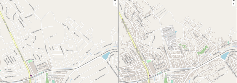
Before and after comparison of mapping in the area following Map2Mitigate activities: on the left, scarce data; on the right, streets, buildings, and pathways mapped by the community in OpenStreetMap.
In favelas specifically, urban growth was even more pronounced, increasing 3.4 times over the same period. Due to a lack of safe housing alternatives, this growth frequently occurred in risk-prone areas, meaning climate vulnerability was felt disproportionately by the poorest populations. As a result, favelas were most exposed to landslides, mudslides, flooding, waterlogging, and waterborne diseases. These areas are also poorly mapped in OSM and, due to their dynamic occupation patterns, are often underrepresented in official cartography.
A partnership between university, community, and open technology

Using and experimenting with open mapping tools, including iD Editor, Tasking Manager, Mapillary, OsmAnd, StreetComplete, Everydoor, +Lugar, ChatMap, Open Aerial Images, and DroneTM, the Map2Mitigate project, developed by YouthMappers UFBA (Bahia, Brazil) in partnership with HOT and TomTom, prioritized training local actors (e.g., community leaders, youth, community agents, and civil defense technicians) in mapping urban areas where the population most vulnerable to socio-environmental disasters, such as landslides, flooding, and waterlogging, resides. By mapping these areas, participants gain a better understanding of the context in which they live and the risks they face, which are significant steps toward rights advocacy and active participation in emergency planning. The project was carried out in four phases: preparation, fieldwork/operations, training, and synthesis, with the last three phases constituting the training process. All four phases were implemented in each of the three project communities, selected due to complementary projects already underway at the university: Osório (Salvador), Marielle Franco and Alto da Conquista (Simões Filho), and Baixa de Santa Rita (Salvador).
Preparation: local coordination before entering the field
During the preparation phase, the team planned activities and coordinated with local actors. Contacts were made with civil defense authorities and other stakeholders, and educational materials were developed for the training activities.
Field/Operations: drone flights and orthoimages to see the territory
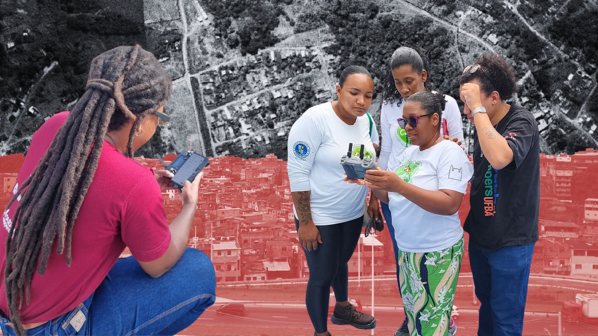
During the field phase, drone (RPA) flights were conducted using ground control points to collect geospatial data. Workshop participants carried out local outreach to promote the activity and accompanied the team on flight day. From these images, orthomosaics and Digital Terrain Models (DTMs) were generated using the OpenDroneMap platform. The data were then uploaded to OpenAerialMap, broadening access to and usability of the collected information.

Community residents closely follow drone control during aerial mapping flights.
Training: open tools in the hands of those who live with the risk
Training activities were conducted with a focus on collaborative mapping. Participants visited university laboratories where they were introduced to mapping equipment, took part in discussions on climate change, disasters, and risk, and conducted field visits using different mapping tools, Mapillary, OsmAnd, StreetComplete, Everydoor, +Lugar, and ChatMap (each group tried one or two of these tools), and contributed to OpenStreetMap (OSM) mapping through the Tasking Manager (in a project created by TomTom). Vectorized data were also validated to ensure quality and accuracy.
Young mappers at the UFBA laboratory during open mapping tools training activities.
Synthesis and sharing: knowledge returns to the community
Throughout the process, a project website was developed at https://sites.google.com/view/map2mitigate/ featuring photo documentation, activity details, educational materials, and participant testimonials from each community. Potential risks were identified to inform actions by public authorities and local agents. Finally, processes and outputs were shared and discussed with participants, fostering collective learning and transparency.
With the training they received, residents of Osório, Ocupação Marielle Franco, and Baixa de Santa Rita gained tools to better identify risk areas and their conditions.
Four young project representatives had the opportunity to meet with the Civil Defense team in Salvador and demonstrate their knowledge. The meeting was a success, and by the end of 2025 a cooperation agreement was signed between the Federal University of Bahia and the Civil Defense, which included the expansion of Map2Mitigate to the municipality's Nupdecs Mirim (Community Nuclei for Civil Protection and Defense).

About the authors
Pedro Melhado is a geographer and master's student in Spatial Information at the Graduate Program in Civil Engineering at UFBA (PPEC-UFBA). He leads the YouthMappers UFBA Chapter and is a voting member of the Humanitarian OpenStreetMap Team (HOT). He works on cartography projects focused on collaborative mapping, disaster risk reduction in communities, community mapping training, and the use of open data in favelas.
Patrícia Brito holds a degree in Architecture and Urban Planning from UFBA, a master's in Geography from UnB, and a PhD in Spatial Information from the Escola Politécnica at USP, with a sandwich period at Louisiana State University (USA). She has worked at CONDER, the Ministry of Cities, NGOs, private companies, and universities. She is an Associate Professor and coordinator of the Cartography and GIS Laboratory at UFBA. Her research covers spatial analysis in public health, favela mapping, collaborative mapping, remote sensing, and new geotechnologies applied to water resources, disasters, and informal urban areas.
Share
