




HOT’s Eastern and Southern Africa Open Mapping Awards 2026
Are you using open mapping to solve a real problem in your community? The Humanitarian OpenStreetMap Team (HOT) Eastern and Southern Africa Hub Open Mapping Awards 2026 recognize groups and organizations that use open mapping to build more resilient and inclusive communities.
Why these awards?
Across Africa, many roads, schools, health facilities, water points and drainage systems are missing from maps. Without this data, it is harder to plan services, prepare for disasters and respond to climate change.
Local mappers are already changing this. They use open mapping and local knowledge to create open data that communities, governments and humanitarian groups can use.
These awards recognise that work. We are not only asking how much you mapped. We want to know:
- What problem did your mapping address?
- Who took part?
- What changed because of your data?
- Will the work last?
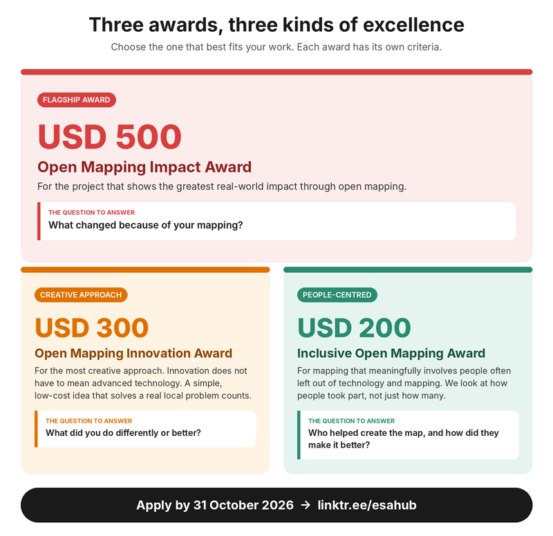
Three awards, three kinds of excellence
Each award has its own criteria, so you compete with projects like yours. Choose the one that best fits your work.
Who can apply
You can apply if you are based in Eastern or Southern Africa and you are:
- A group of mappers, such as an OSM community or a university student group
- An organisation: government, private or nonprofit
Your project can be completed, ongoing, or a pilot with promising results. It must publish or use data on OpenStreetMap, OpenAerialMap or another open data platform.
Projects that use HOT tools, approaches or data are welcome. This is a plus, not a requirement.
How the jury will choose the winners
The jury looks at four things in every application.
- Problem. What local problem did your mapping address?
- People. Who took part, and what role did they play?
- Change. What changed because of your data? Who used it?
- Lasting value. Will the data and the work continue after the project?
Each award then puts the most weight on its focus.
- Open Mapping Impact Award: real-world change.
A strong application shows clear proof that people used your data. For example, to plan a service, prepare for a flood or respond to an emergency. - Open Mapping Innovation Award: a new or better way of working.
A strong application shows what you did differently, why, and whether it worked. - Inclusive Open Mapping Award: how people took part.
A strong application shows who helped make the map, what they decided or did, and how their knowledge improved it.
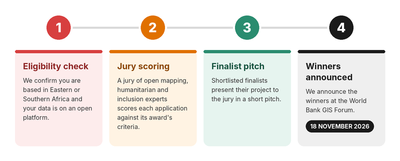
The selection process
What to share with us
You don’t need GIS or proposal-writing experience. Plain words are welcome. Show us what your work achieved. Evidence can include:
- OpenStreetMap campaign links
- The number and type of features you mapped
- Maps, dashboards or before-and-after examples
- Photos from the field
- Community feedback, or partner and community endorsements
- Proof that you used your data, or that others used it, for impact
- Reports or other project documents
Key dates
Applications are open now and close on 31 October 2026. From 1 to 14 November, we will check every application and the jury will score them. We will announce the winners on 18 November at the World Bank GIS Forum.
How to apply
- Start by reading the three award categories and choosing the one that best fits your work. Then write your answers in a document first and gather links to your evidence, such as OpenStreetMap campaign links, maps, photos, or reports. This makes the form quicker to fill in.
- When you are ready, go to linktr.ee/esahub and choose your award category. Fill in your details, answer your category’s questions, and submit by 31 October 2026.
- For full details on eligibility, criteria, and what to include, read the awards guidelines.HOT's Eastern and Southern Africa Open Mapping Awards 2026 (2)
Questions?bEmail us at esahub-info@hotosm.org.