Mapping Tropical Storm Ana and Cyclone Gombe in the Most Affected Districts of Malawi for Early Recovery of Affected Communities
Community-Led
Tropical Storm Ana, which made landfall in Malawi on 24 January 2022, caused heavy rainfall and strong winds in several districts in Malawi. In the aftermath of the TS Ana, Cyclone Gombe also hit the same districts in March 2022. As a result, houses, road networks, hydroelectric power stations, schools, and health facilities, among others were destroyed. This project, supported by HOT and implemented by the Malawi Red Cross, Nkoma University, and local OSM Communities, provided updated geospatial information on infrastructure and historic flooding extents in the affected districts of Chikwawa and Nsanje.
The primary goal of this project was to develop effective mechanisms for mitigating climate change-related disasters by generating geospatial data critical for disaster recovery, planning, and decision-making. Active community participation is a key component of this project to ensure that the actual areas are accurately displayed on the map. Baseline studies were conducted through Focus Group Discussions to identify the hotspots of damage caused by Tropical Storm Ana and Cyclone Gombe.
To better understand the challenges faced by the affected communities, the project conducted induction meetings with local councils in Chikwawa and Nsanje districts. During the induction meeting, the project successfully engaged 110 members, who participated in the study area identification and awareness.
During the Focus Group Discussions, the project team gathered valuable insights on the detrimental effects of climate change-related disasters on local communities, with several stories being cited. For instance, in Nthumba, a community in Chikwawa, floods had occurred for the first time, leaving a student from Nthumba primary school unable to attend school for over three months due to unsafe travel conditions and flooded school blocks.

Moreover, the floods also affected a school for the blind in Nsanje, making it challenging for students to find shelter. According to the chairman of the Nsanje VCPC, over 5,000 households were affected and destroyed by the water in Nsanje.
Malawi Red Cross Society together, Nkhoma University and Malawi OpenStreetMap, organized the first ever training on OpenStreetMap where trainees were introduced to the iD editor for mapping. This was followed by a mapathon in November 2022 in partnership with Lilongwe University of Natural Resources and Agriculture (LUANAR) where 20 females and 25 males were involved in mapping 100 buildings and 40 km of roads. Through this project, Nkhoma University was accepted to join the Youth Mappers Chapter.
Despite challenges, such as a lack of experienced mappers in the country, many students are willing to contribute to mapping. The project has trained 22 students (10 female and 12 male) in OpenStreetMap, and one student, Winstone Nkhoma, managed to make 36,840 changes within 14 days, currently ranking second among the 500 contributors in Malawi.

The project through Participatory mapping has enabled the communities to understand their hazards, capacities and vulnerabilities. Mapping floods with satellite imagery and local observations proved useful to compliment each other. In the future, online mapathons would be useful to reach a wider audience and Youth Mappers will be more engaged.
The team also delineated flood water extents for flooding events since 2019 in Chikwawa and Nsanje districts using Google Earth Engine. A map box was developed and using the capabilities of ESRI’s Africa Geospatial Portal tool interactive maps were developed and shared on a GitHub page for OpenStreetMap Malawi and it is accessible here: https://osm-malawi.github.io/floodmapping/
The infrastructure data and flood extents will act as baseline data to help the councils in future flooding events as they know the number of key infrastructures such as buildings before and after the disaster. The community based organizations have been trained on the relevance of spatial data in disaster preparedness and response.
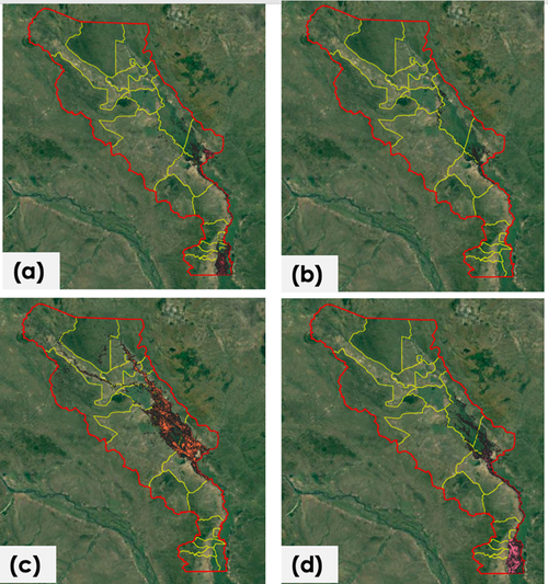
Flood water maps for major flooding (in red) in Nsanje and Chikwawa since 2019, with (a) representing Cyclone Freddy, (b) Cyclone Gombe, (c) Cyclone Ana and (d) Cyclone Idai.Yellow are administrative boundaries.
