Myanmar Earthquake Response 2025
Conflict & Displacement • Myanmar
In March 2025, a destructive earthquake hit central Myanmar. In response, HOT in partnership with Myanmar OpenStreetMap Community (myOSM) launched a mapping initiative to fill data gaps in OpenStreetMap. Now, through funding from the H2H Network, myOSM will be able to scale their mapping and HOT will support improved data use of humanitarian partners in the region.
Table of Contents
Background
Destructive earthquakes on 28 March 2025 in Myanmar exacerbated an already prolonged and complex humanitarian situation. Measuring the impact of the conflict and now earthquake, is challenging due to the limited information coming from those affected, which makes it hard for humanitarians to plan resources or respond.
Accurate and rapid building damage assessment play a critical role in the aftermath of disasters to guide rescue efforts, humanitarian aid, and disaster recovery. However, in the Global South, up-to-date map data – particularly in remote and rural areas — are often not readily open or available.
As seen with Myanmar’s recent earthquakes, decades of military rule have led to challenges in information and data sharing. At the onset of the disaster, OpenStreetMap (OSM) buildings data gap stood at 85.93%, in an area that hosts an estimated population of 41,670,509 persons. Data gaps in OSM buildings compromises the reliability of AI-driven damage assessments like from Microsoft AI4G Lab.
HOT has been leading a campaign called "Myanmar Earthquake 2025" to improve building footprint coverage. You can find more info in the wiki page. Below are some of the stats related to this campaign as of 2 June 2025.
Tasking Manager Projects and Statistics
1,662,712
Total Edits
2,996
Contributors
1,121,907
Δ Buildings
Approach:
The project will focus on filling in gaps in vital OSM data in target affected areas and develop comprehensive building footprint data in Sagaing Region, Mandalay Region, Nay Pyi Taw Region, Bago Region, and Magway Region to understand impact and inform early recovery.
1) Remote Data Collection: Skilled mappers will remotely map building footprints and roads (roads to be determined) using HOT’s Tasking Manager to expand and improve the quality of baseline open map data across the affected areas.
2) Local Data Validation: data quality checks by Burmese diaspora members who are familiar with local building structures and HOT’s OSM community.
3) Open Buildings Datasets Source Comparison: By request from HDX and in consultation with key humanitarian actors, an agile comparison framework to identify best building footprints data sources (OSM, Google, Microsoft, and Overture) available across different phases in the disaster response.
The project will also leverage open source MapSwipe and Tasking Manager to identify areas of building damage in priority affected areas in Mandalay and Sagaing, and conduct comparisons across several damage analyses to support life-saving humanitarian aid and recovery efforts by building a complete map of infrastructure status to enable returns and avoid potential prolonged displacement.
State of the Data, Data Access and Use
Various data sources contribute to building footprints, including open data from Google, Overture, Microsoft, and OpenStreetMap (OSM). While all the other sources draw data from AI, OSM stands out for its human validated workflow, the fact that it is community-driven and the diversity of the contributors.
OSM
OSM data can be downloaded from HDX. Scroll through this filtered HDX list or choose from the categories below to visit a specific dataset: - Roads - Buildings - Waterways - Railways - Health Facilities - Financial Services - Populated Places - Education Facilities - Sea Ports - Airports - Points of Interest
Overture
The Overture Maps Foundation dataset (licensed under the Community Database License Agreement – Permissive v2) combines OSM buildings with machine-mapped footprints from Google and Microsoft. The data is available for exploration and download here, but updates to OSM data occur roughly monthly (check the latest update here), meaning recent OSM edits won’t appear immediately.
After the Myanmar earthquake, Overture shared its Myanmar building footprints on HDX. However:
-
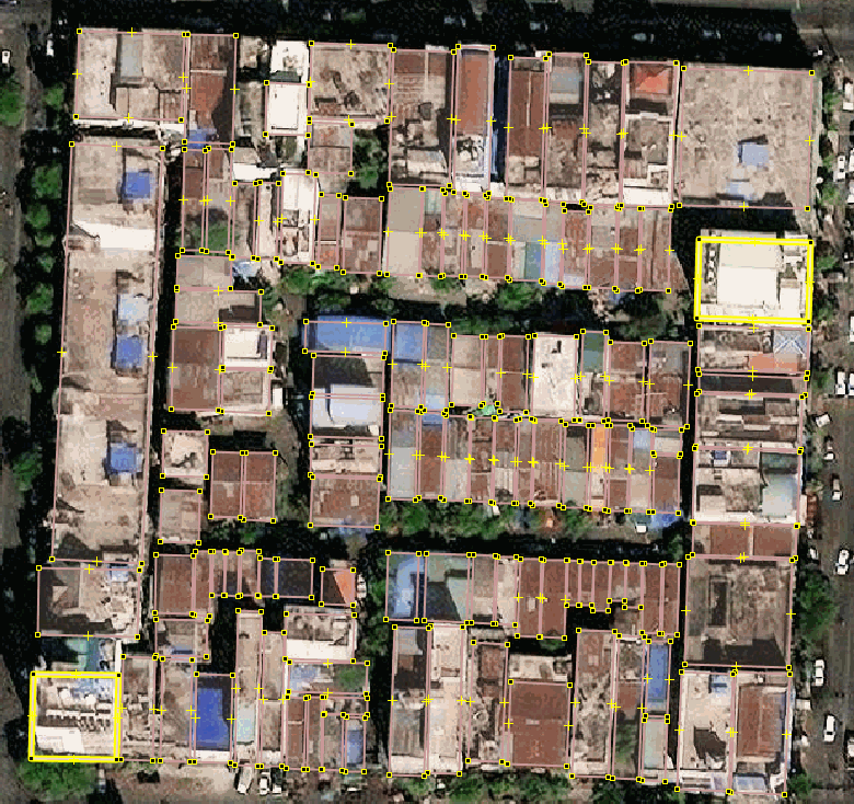
In densely built areas like Mandalay, Overture’s machine-mapped footprints may be less accurate or complete than OSM’s manually mapped data (see comparison GIF in the original text).
-
In rural areas, Overture misses ~⅓ of settlements detectable via satellite imagery, as shown by MapSwipe project results where volunteers identified built-up areas.
![]() This project was funded by the H2H Network’s H2H Fund, which is supported by UK aid - from the British people.
This project was funded by the H2H Network’s H2H Fund, which is supported by UK aid - from the British people.

.png)