Rio Grande do Sul, Brazil Floods Response
Disaster Response • Porto Alegre • Community-Led
Following the collapse of the July 14th hydroelectric dam in Rio Grande do Sul, Brazil, which exacerbated severe flooding and left over 100 dead and more than a million people affected, the OSM Brazil Community and the Open Mapping Hub in Latin America and the Caribbean initiated a response on May 9th, 2024. This effort led to the completion of 22 mapping projects, covering extensive areas and infrastructure, and facilitated a crucial partnership with the Inter American Development Bank (IDB), an international development finance institution, to support recovery and provide valuable tools for the community in Porto Alegre.
Mapping projects for this activation
Wiki page for this activation
CONTEXT
After two weeks of intense rain, gales, and hail in Rio Grande do Sul, Brazil, the collapse of the curtain of the July 14th hydroelectric dam has exacerbated an already critical situation, resulting in more than 100 deaths and 100 missing. More than one million people are affected. Nearly 70,000 have been evacuated and over one million homes are without drinking water. Additionally, 421,000 households lack electricity, and 115 municipalities are without telephone and internet services. There are 61 blocked roads and the Porto Alegre airport remains closed. The Guaíba River has reached record levels, flooding the historic center of Porto Alegre. The current estimated river level is 5,33 meters.
This event marks the second significant disaster in less than a year for the state, following a cyclone in September 2023 that left at least 31 dead. Climate change, along with the El Niño phenomenon, has intensified extreme weather conditions in the region.
APPROACH
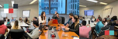
After the natural hazard disaster, the OSM Brazil Community, in coordination with the Open Mapping Hub in Latin America and the Caribbean, decided to initiate an activation on May 9th, 2024, to bolster response efforts. This decision followed consultations with local partners and ongoing efforts to identify and prioritize data needs. Our focus was on mobilizing the OSM Community and the Humanitarian Mapping Brigade to map and validate tasks, establish communication with Civil Defense to assess their geographical data requirements, and negotiate access to satellite imagery.
From June 15 to July 15, 2024, the LAC Hub collaborated with the Inter-American Development Bank (IDB) and the departments of education, health, sports, and social assistance of the Porto Alegre government to address flood damages. This collaboration centered on developing and testing an initial georeferenced assessment method for affected facilities and systematizing data. It also proposed a participatory campaign for cartographic monitoring of recovery efforts in the months ahead. The primary objective was to support local initiatives in crafting and executing reconstruction and transformation plans in the worst-affected areas, emphasizing community involvement and ensuring an inclusive, sustainable approach.
Led by Céline Jacquin, Everton Bortolini, and Juan Melo, the HOT team devised a survey methodology to assess damages to public and social infrastructure. This tool was co-designed with local officials and civil engineers from the IDB to gather critical information for municipal authorities and funders alike. The damages were extensive, with buildings submerged up to three meters for over a month, resulting in severe material and structural impairments, and total losses in numerous cases.
As the initial emergency response transitioned to recovery and rebuilding phases, it became imperative for local authorities to ascertain the current status of infrastructure in education, healthcare, and social services. These facilities had suffered varying degrees of damage, particularly in the most vulnerable urban areas. Detailed facility data was essential for estimating recovery costs, initiating procurement procedures to expedite reconstruction, and establishing monitoring mechanisms. To facilitate accurate on-site assessments and provide tailored support, IDB and HOT joint mission was dispatched to Porto Alegre. Both organizations are exploring ways to sustain this effort beyond the emergency.
OUTCOME AND IMPACT
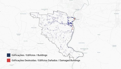
uMap created by the HOT team to visualize mapped buildings and destroyed structures.
This effort concentrated on updating the already comprehensive maps in the hardest-hit areas and securing access to post-disaster imagery.
To date, 22 mapping projects have been completed (see Wiki for more input), encompassing 55,629 buildings; 2,326 km of roads; 2,062 km² of mapped area; and 8,612 mapped tasks. This initiative fostered a vital partnership with the Inter-American Development Bank (IDB). Together, we focused on generating and collecting high-quality geographic data for the Porto Alegre prefecture and assisting in the damage assessment of public facilities which will allow development agencies and the local government to target funds to the most relevant needs. Additionally, we are developing new interfaces that offer valuable tools to the community, enhancing response efforts in the most affected areas.
