Tracking Flooding in Rural Liberia
The Commonwealth District in rural Liberia is home to Lake Piso, a crucial hub of biodiversity covering an area of 103 km2 and the Atlantic Ocean. However, heavy rainfall and high sea-level rise severely affect towns and villages along the lake's banks and coast.
HOT's regional hub partnered with the government, local communities, and disaster resilience actors to generate vital, insightful datasets to support decision-making and derive mitigation programs. The project’s outputs empower response actors and local communities to develop resilience initiatives to reduce the devastating impact of flooding and sea-level rise over the past three decades. This is the first time such tools have been available to national emergency actors in Liberia.
Objective
Liberia's coastal settlements cover a distance of 565 kilometers and are mainly lowlands characterized by mangroves and swamps. These settlements are exposed to extreme climate hazards such as flooding, rising sea levels, and coastal erosion. The area is home to nine significant rivers that flow through vast estuaries into the Atlantic Ocean. Seven coastal cities, including Monrovia, experience over 500mm of average annual rainfall, often leading to floods and sea erosion. These events disrupt livelihoods, damage properties, and impact public infrastructure.
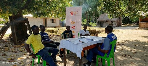
The project objectives included: * Engage stakeholders and communities in understanding climate change impacts and building resilience. * Conduct impact assessment, data needs, and use case surveys. * Host workshops and focus group discussions with local stakeholders, women, and youth groups to understand the impact, hazard, exposure, and risk posed by flooding * Recruit and train the district youth to carry out remote mapping field data collection. * Conduct awareness campaigns on climate change impact and adaptation through local community radios. * Conduct desk review for additional datasets to support analysis * Technical stakeholders will be trained on project tools and methodology to promote sustainability. * Conduct routine communication and develop a video documentary of the project’s impact. * Share project datasets with stakeholders in an open format and printed maps as an offline decision-making tool * Develop a web map and upload non-identifiable datasets to OpenStreetMap
Robertsport, located in Grand Cape Mount County in western Liberia, is one of the country's oldest and most beautiful cities. The district comprises Talla, Upper and Lower Tumbey, and Robertsport clans, covering an area of 391.377 km2 with over 30,000 inhabitants.
Disaster and emergency actors, including the Disaster Management Agency, Liberia National Red Cross Society, Environmental Protection Agency, Ministry of Internal Affairs, the local authority, and several civil society and community-based organizations, work year-round to support disaster management and their impact across Liberia. However, access to reliable and analyzed data hinders disaster mitigation, preparedness, response, and recovery initiatives.
Through the Tracking Flooding in Rural Liberia project, these national actors can now develop resilience programs to support the people of the Commonwealth district in Grand Cape Mount County. Furthermore, these stakeholders desire to utilize the tools and workflows learned through the project's capacity-building activities to scale up to other affected counties across Liberia.
“Owing to the lack of reliable data, we have encountered difficulties raising awareness about climate resilience. We have primarily concentrated our efforts on urban communities. However, the Tracking Flooding in Rural Liberia initiative can provide us with critical information to steer our preparedness and response initiatives. This project will also enhance our policies in tackling climate-related concerns”. - Henry O. William, Executive Director of the National Disaster Management Agency
Many rural communities across Liberia should be included in national efforts. Therefore, the project served as a wake-up call to address these rural communities' plights, impact, and devastation.
The project addressed stakeholders’ data needs through an Open and Participatory approach, emphasizing hazards, exposures, and risks to the inhabitants, public infrastructure, service delivery, building materials, types, and solid waste management.
Approach
What methodologies did we use? * Stakeholders mapping, engagements, and Workshops * Focus Group Discussion with local community leadership, youth and women groups * Remote mapping and field data collection * Climate resilience awareness through local community radio * Data analysis and map product development capacity building of technical stakeholders and local community youth * Acquire third-party data to support in-depth analysis
What tools were used: * Tasking Manager - was used for remote mapping activity * Central Server - ODK Central server was used to authenticate store data * JOSM- was used for data cleaning and validation * Quantum GIS - QGIS was used for data analysis and visualization * Open DataKit - was used for field data collection * HOT Export tool - to export data from OSM by stakeholders
What datasets were collected: * Buildings( materials type, roof type, foundation - height) * Roads and waterways * Infrastructure (financial, healthcare, education, public toilet, markets, cemetery, public buildings) * Drainage network (drain segments, coverts, * Solid Waste (formal, informal dumpsites)
The project obtained boundary shapefiles from the Liberia Institute for Geo-Information Services (LIGIS) and flood hazard data from Fathom Global. Additionally, we acquired qualitative data from the inhabitants of the project area through Focus Group Discussions and from stakeholders through data needs and use case surveys.
Outcome and Impact
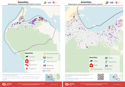
Data Added to OSM: * Buildings (Remote mapping covers all five districts; previous mapping was done during the COVID-19 Rapid Response project = (18,922 new buildings added) * Cemetery = 33 * Drainage network (drain segments) = 37 * Education = 46 * Financial services = 18 * Markets = 4 * Public toilets = 70 * Waste disposal sites (formal, informal) = 59 * Water points = 164 * Flood history (spot check representing communities)= 146
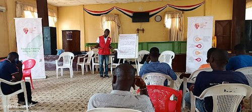
A total of four training sessions were conducted: * Field mappers and remote mapping * Local technical stakeholders and youth * National Stakeholders Capacity building * Revamping the OSM community
Lessons Learned and Next Steps
Liberia's coastal settlements cover a distance of 565 kilometers and are mainly lowlands characterized by mangroves and swamps. Eight more coastal capital cities are also exposed to extreme climate hazards such as flooding, rising sea levels, and coastal erosion and need similar intervention.
The success of this project was mainly due to the involvement of the local community from the beginning. Crucial factors for achieving success include designing, planning, executing, and communicating promptly. All stakeholders took on some form of responsibility for the project and supported every aspect of its implementation. Additionally, the project prioritized localization by emphasizing training and involving the youth and other crucial stakeholders as implementation team members.
This approach is vital for every project. When the project is based on community needs and involves community members and technical stakeholders in every phase, it leads to collaborative support and inclusion. Moreover, through the Focus Group Discussion approach, ordinary inhabitants impacted by the project can feel reflected in the project's outcome.
Media
Map of the Project Area and Added Data