Women Centered Disaster Resilience in Small Island Developing States - Montserrat
Montserrat
Young women from Montserrat were trained on how to use HOT Tasking Manager and participated in a mapathon to map critical facilities on the island that are vulnerable to climate change impacts.
Background: A budding OSM community in Montserrat
After the creation of the OpenStreetMap (OSM) Caribbean Chapter in Barbados, Lavern Ryan, founder & CEO of LRR Geospatial Consultancy, saw the opportunity to expand the community in Montserrat by introducing OSM to interested young girls from the Montserrat Secondary School (MSS) and the Montserrat Community College (MCC), as well as other women in the population. The goal was to add critical facilities on the island to OSM using the HOT Tasking Manager, considering that Montserrat, like other islands in the Caribbean, is vulnerable to many climate-driven impacts.
<small>View Larger Map</small>
Approach: Finding women mappers
The first part of the project involved recruiting young women interested in learning OSM for climate resilience in Montserrat. This was done through various means: social media posts, flyers hung on Montserrat’s Secondary School, live interviews on a radio show, and directly contacting Geography and Environmental Science teachers and students at the Montserrat Community College.
After the recruitment phase, a two-day event was held. Although 14 persons had originally registered, a total of 20 persons assisted to the events. The first day focused on training the attendees, during which each created an OSM account, explored projects in the HOT Tasking Manager, and started working on tasks for this project. The second day consisted of a full-on Mapathon. After its conclusion, attendees received a certificate of participation, and a prize-giving ceremony was held.
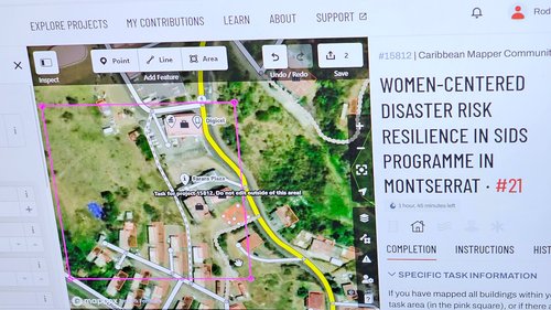 Snapshot of the HOT Tasking Manager project that was created for use during the mapathon
The project organizers also requested participant feedback and created a What’s App group called “Montserrat Mappers,” where future training opportunities and online events will be shared.
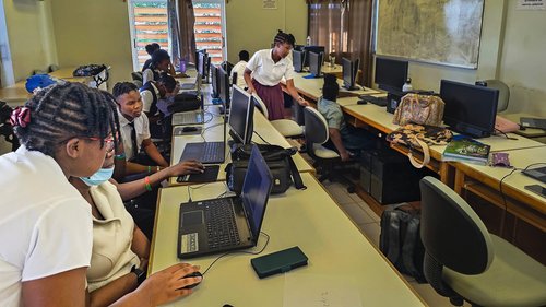 Mapathon attendees working on the tasks assigned by the organizers
Impact
As a result of this project, there were:
| 16 | 4 | 159 |
| Women trained on OSM | Men trained on OSM | OSM changesets |
This project focused on mapping critical facilities (structures) to aid in disaster relief and recovery. The team considered mapping structures using polygons to be more suitable as introductory training for the participants' current skill level.
"Learning this new skill was very fun for me, being able to contribute to this initiative that will help with identifying areas on Montserrat that are vulnerable to impacts of various systems is very fulfilling."
— Feedback from one of the trainees
"A very interesting event as working with the environment is a major part of my career, being able to contribute to GIS on Montserrat is something I often think about and this training has made it possible to delve a bit more into the field. Definitely looking forward to more events like this."
— Feedback from one of the trainees
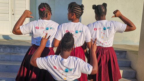 Trainees show the customized shirts designed for the project
Learning from experience
Following the conclusion of this project, LRR Geospatial identified the following recommendations:
-
The event duration (in terms of the number of days and hours) could have been extended by another day to allow participants to fully complete the tasks without feeling rushed.
-
Other tools for updating OpenStreetMap can be employed in another iteration.
-
Persons unable to attend physically can be engaged via a virtual mapathon.
Photos by LRR Geospatial
