Indonesia’s Mapping Design Competition: LOKAVISTA
Posted by Adhitya Dido Widyanto • Dec. 18, 2020
From September to November 2020, HOT Indonesia organized a mapping design competition called LOKAVISTA for university students across the nation. Our mission was simple: to increase the public awareness that OpenStreetMap data can be utilized for many purposes and different aspects of life.
The Beginning
We came up with the idea based on eight years of experience doing various training and mapping that focused on adding more OpenStreetMap data in Indonesia. In that time, we successfully gathered more than 30 million buildings and more than 1.4 million kilometers of roads mapped in Indonesia.

As the amount of data keeps increasing, we are shifting our focus to not only add more data, but to emphasize how people (especially in Indonesia) can use OpenStreetMap data for their own purposes for free.
To do so, we created a mapping design competition targeting university students in Indonesia. The main idea was to challenge them to make a decent and informative map with OpenStreetMap data as their primary source of data.
Why university students? HOT ID has already had a strong relationship with a lot of universities in Indonesia since 2014, and we wanted to maintain this relationship into the future. Plus, uni-students are the most suitable participants based on their current education level, creativity, and eagerness to learn.
We used this reference from SDG’s as the theme of this competition:
“Using OpenStreetMap data to support Sustainable Development Goals (SDGs) through the creation of online or offline based maps.”
Each participant selected one of the following sub-theme on their map:
- Public Health (COVID 19)
- Water & Sanitation
- Poverty Elimination
- Disaster Respons
- Environment
- Clean Energy
- Transportation
- Sustainable Cities
We divided the competition into two categories, ‘Web-GIS Map’ (online map) and ‘Desktop Map’ (offline map). Each participant could only select one category.
Timeline
We started the competition on 16 September 2020 with a teaser poster to the public that something great was coming.

A week later, we officially announced the competition and started the ‘Registration Round,’ going from 21 September until 11 October 2020.
To increase the number of participants, we held a promotion webinar on 29 September, attended by more than 50 people.

Started from 5 October until 1 November, participants who already registered their team could submit their map design on the ‘Submission Round’.
We announce the winner on 20 November 2020 during our OSM Geoweek virtual event.


The Competition
We received so many interesting ideas of how OpenStreetMap data could be used and transformed into various types of maps for different purposes.
During the registration period, we had 41 applicants for the competition: 21 teams for ‘Web-GIS Map’ and 20 teams for ‘Desktop Map’.
Later on, 23 teams submitted their map design: 13 teams for ‘Web-GIS Map’ and 10 teams for ‘Desktop Map’.
Sustainable Cities, Public Health (COVID-19), and Disaster Response were the most popular themes in this competition.
Result
It was quite fun and exciting to see our participants giving their best to design and create quality maps based on OpenStreetMap data. We were amazed by their thought and creativity on what they could do with those open-source data.
After much deliberation, we came out decide on the winners of the LOKAVISTA 2020 competition:
Web-GIS Map
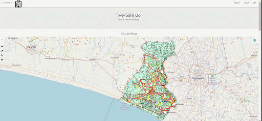
1st Winner: Sugar Daddy https://s.id/sugar-daddy
.gif)
Our first winner from the ‘Web-GIS Map’ category created something that astonished us. They used the building data from OpenStreetMap combined with other supporting data to visualize solar energy’s distribution capacity on each building roof in Bandung, West Java, Indonesia. They created this map as a solution to provide clean energy in Indonesia.
2nd Winner: Apren - GIS https://s.id/apren-gis

An interesting visualization of water and sanitation facilities and access in East Nusa Tenggara, Indonesia. They managed to use various OSM data such as health facilities, waterways, and land-use to visualize it into an informative online map.
3rd Winner: JATEOTO https://s.id/jateoto
We can see how OpenStreetMap data can help you locate the nearest health facilities from public facilities nearby, related to COVID-19 situation. This team used health facilities, public facilities, and road data from OpenStreetMap as their primary data source.
Desktop Map
1st Winner: LAVAGAMA https://s.id/lavagama

Lavagama team created a magnificent work on their map design. They chose disaster response as their topic on the map and utilize various types of OSM data such as waterways, shelters, and roads. Moreover, they did a field survey to complete the information they needed. As a result, they create an excellent and informative map that helps us identify the disaster-prone areas of a volcano eruption in Mt. Merapi, Yogyakarta, Indonesia.
2nd Winner: Tim E-Zone https://s.id/e-zone

This team utilized land-use data from OpenStreetMap and other supporting data to analyze the most potential site to build a factory, based on the land-use data taken from OpenStreetMap. It’s one of the great examples of how OSM can be used as a powerful tool for a decision-making process.
3rd Winner: Tim Tiga UGM https://s.id/tim-tiga-ugm

A great visualization of a disaster risk analysis map of flood in Semarang, Central Java, using land-use and road data from OpenStreetMap.
The winner announcement was made at Indonesia’s OSM Geoweek Virtual Conference, 20 November 2020. You can see the recorded video on our Youtube Channel: OpenStreetMap Indonesia (only available in Bahasa).
We were really thrilled with all the ideas and maps that were sent by the participants. This activity gave us a bigger picture of what OpenStreetMap could do with its open-source geospatial data.
Not only as a tool that could put everyone on the map, but it could be really insightful to visualize and create thematic maps on any related fields.
With all of these possibilities, we do hope that we can do the same competition in the future, but, on a larger scale with different target audiences.
Share
