News — 02 October, 2022
Kicking off the Data Quality Internship 2022!
Another year, another Data Quality Internship!
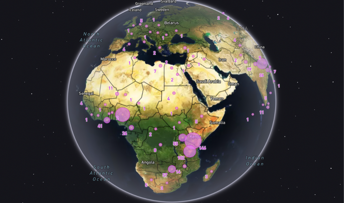
The Humanitarian OpenStreetMap Team’s (HOT) Data Quality Internship has been an annual program since 2020. The 2022 Data Quality Internship (DQI) years program will host 28 interns from 18 countries, and will build on the successes and lessons learned from past programs.
This year’s DQI aims to:
- Build trust and transparency in OSM data
- Build capacity across our validator networks in HOT’s focus countries
- Provide learning opportunities for mappers wanting to take their mapping skills to the next level
- Contribute to building a sustainable community of OSM Validators to ensure continuity of data flow and maintenance in OSM
- Contribute to diversifying our existing network of valued validators
- Prioritize validation of already existing projects on HOT’s Tasking Manager
This year we had an incredible 1008 applications from 81 countries. Of the applicants, 38% identified as a woman, 59% identified as a man, 1% as non-binary and 2% preferred not to say.
Through a rigorous recruitment process, supported by HOT’s HR team - the DQI Coordination Committee selected applicants for interview, with the intention of selecting 30 interns from October - December 2022.
Introducing DQI Interns
Daniel Osei Agyeman
My name is Daniel Osei Agyeman, and I’ve been a young mapper since 2016. During the GIS celebration day in 2016, I joined YouthMappers while in level 200 at the University of Cape Coast. Since the day I learned how to map with JOSM, I’ve been an active mapper. I’ve worked remotely on a few projects, including 390 tasks on COVID-19 - Yelimane Cercle 4 - Kayes Region, Mali and 136 on Missing Maps: Zimbabwe Malaria Elimination 8. Professionally, I have mapped areas both internationally and in Ghana. I’ve mapped a number of locations in the Northern, Central, and Greater Accra regions.
While working on various field projects in Ghana, particularly in the north, I became acutely aware of the use of the data that we generate remotely, as well as the difficulties that arise when such data is of poor quality. I am inspired to participate in this internship in order to obtain more information and abilities to help me generate more quality data to help both on-field and off-field professionals in their area of work. Also, the fact that I can share the information I receive here with my local youth mappers chapter so that we can continue to develop quality data to be utilized to tackle challenges in our society.

Sangeeta B.C.
I am currently pursuing a Bachelor’s degree in Geomatics Engineering at the Paschimanchal Campus in Pokhara. I am the current secretary of the Geomatics Engineering Students Association of Nepal (GESAN). Regarding my OSM journey, I initially heard about OSM during my first semester. After learning about the diverse applications of mapping, I was inspired to get involved. I am currently an Advanced OSM mapper, and have participated in numerous OSM events. I am also a champion of the SLSI program. I am motivated to participate in this excellent opportunity to learn more about OSM and to learn how to provide quality data for humanitarian purposes.

Japhet Masunzu
OSM contributor since 2020
My Professional mapping experience
- Import and digitization of buildings in DRC
- Collection of cartographic data of boundaries and health structures in the territory of Beni, their integration on the OSM server and quality control of these data integrated on the server (Tools: OsmAnd, Osmtraker, JOSM)
- Digitization of roads in North Kivu
- Participation in Africa Mapathon mapping sessions (Liberia; Lesotho; Morocco)
- Assistant trainer in two training workshops on the tools of collection, processing of cartographic data and production of maps organized by OSM DRC
Through this program I would like to improve my knowledge of OpenStreetMap data validation and quality control tools and share this knowledge with other contributors so that together we can contribute to the quality of OSM data and it can be used effectively for community development.

Eray Öztürk
I joined my mapping life at a Missing Map event in 2017. I just started mapping with the OSM id Editor. I didn’t do much mapping until I met the Yer Çizenler Mapping for Everyone Association. They taught me about the usage and detail of OpenStreetMap. After a period of time, I volunteered with them and participated in their activities. I participated in the Mapping Unmapped towns in Turkey event with Yer Çizenler and Youth Season. I participated in natural hazard, disaster, and open data studies in partnership with Friedrich-Naumann Foundation, TESEV and Yer Çizenler. Also, I am currently actively mapping on OpenStreetMap.
The reason I joined this program is so that I can now learn more with open data (JOSM etc.). I will be able to help people who need help, even from a distance, as much as I can.

Shabani Magawila
Shabani Magawila used to be the president of IRDP YouthMappers in Mwanza and supervisor at IRDP YouthMappers in Dodoma. He graduated from IRDP with a Bachelor’s Degree in Urban Development and Environmental Management. He has been volunteering for OpenStreetMap and YouthMappers since 2017, including through projects like Ramani Huria as Junior Supervisor, WomenConnect as Validator and GIS Analyst and Mnadani Community Mapping as Project Leader.
Shabani is self-motivated, using GIS and Remote Sensing to help urban, marine, and environmental planners to better plan; and is excited to work with the community and other stakeholders to ensure improved quality of life for both rural and urban residents.
Manish Adhikari
I’m Manish Adhikari, currently pursuing a Bachelors degree in Geomatics Engineering at Paschimanchal Campus, Pokhara. I started my OSM journey with the inspiration from great mappers of GESAN, WRC. I just used to map for fun at mapathons. Then I learned many new things that OSM can play an important role for, such as humanitarian activities, emergency preparedness, project data and many more. Now I’m an Advanced level mapper and have already participated in many mapping projects all over world. I also have a little experience as a trainer for beginner level mappers. I want to expand my mapping skill more, and this internship will be great opportunity for me to reach many milestones in quality mapping and data analysis.

Kingsley Chika CHUKWU
Kingsley Chika CHUKWU is a YouthEmpowerment, Mapping and Training Associate of Unique Mappers OpenStreetMap Community, Nigeria. He is also a HOT-voting member, FIG, NIS and OSMF. He is a National Diploma graduate and about to graduate from the University of Nigeria, Nsukka with a BSc. in Geoinformatics and Surveying.
Experience
- Advanced Mapper
- HOT Validator/ Trainee with 350,000 Edits
- 5 years as OSM contributor
- Surveying and GIS Skills
Motivation
- To gain experience that will match the training needs of local communities of HOT.
- Acquire skills to sustain my volunteering passion.
- Share experience to train others contribute quality data to OSM.
Supath Dhital
Being a geospatial data enthusiast, I am a self-motivated mapper and have more than 2 years of open data experience. Working as a remote mapper at Kathmandu Living Labs (KLL) for numerous national and international projects and continuously volunteering from my side, as well as engaging in many webinars and training others in basic mapping, help me boost my knowledge in mapping.
Promoting the open data, delivering the quality data to the users and by learning the tools and techniques from internship and flow this experience to the new digital volunteers and making quality assured and building a self-motivated community motivated me to join the program.

Gorakh Nath Pandey
Over the course of my OSM journey, I have participated in numerous projects that are relevant to OSM. My professional development has been aided by the training I’ve both received and provided. I participated in the UN mapping training on “OpenStreetMap and humanitarian mapping” as one of the mappers. I was motivated to undertake this internship because I wanted to enhance my mapping profession and spread my knowledge more widely. In order to ensure data quality in the mapping field and to provide more spatial data, I was very inspired to join this program as OSM is most vital for geospatial, disaster response, sustainable communities, and several other significant projects.

Ssekitoleko Derick
Ssekitoleko Derick is a Humanitarian Digital Disaster Responder. He responds to disasters through mapping while creating free Data for humanitarian Organizations. After four years working as a volunteer mapper and validator with OpenStreetMap and Humanitarian OpenStreetMap team, he realized that data produced by beginner mappers is not of a high quality yet. He believes higher quality data is important and needed for better planning. That’s why he decided to apply for the Data Quality Internship program: to gain more skills in providing higher quality data.
He also believes that free higher quality data is one of the fundamental tools in better planning and development; most especially in developing countries like his country of Uganda, where such data is still missing.

Anisa Dhakal
I was made familiar with OSM platform in my first year of Bachelor Degree of Geomatics Engineering through ‘Youth Mapper University Chapter GESAN’. Then, I made my OSM profile on May 13th 2020.
I mapped some of my village area through ID editor. But when my friend introduced me to the HOT Tasking Manager platform and use of JOSM, I was really happy to know that my contributions of mapping were soon utilized for different humanitarian and development purposes through various active and urgent projects. While mapping in my initial year, I had trouble with the tools and plugin and even some technical problem with my updating of works. Then I consulted with my friends and searched for solutions. The more I had to tackle with problem, the more I became interested in it. Still, I am learning to be skilled in mapping and trying to learn some validation skills.
Till now I have contributed to various active projects through the HOT Tasking Manager. I have participated in ‘Field Mapping Tools Workshop’ organized by Open Pacific Hub, ‘Empowering Women In Geospatial Informationen Technology-2022 edition’ by SERVIR Hindu Kush, where I learned about Q-GIS and Remote Sensing. Recently, I had contributed to Remote Mapping Kakamega, Kenya for Transportation Needs Assessment.

Pragya Pant
I am Pragya Pant, HOT data quality intern for 2022. I recently graduated as a Geomatics Engineer from Kathmandu University, Nepal. I have worked as a project manager, co-mapathon analyst & field participant in the projects under Booster Grant and HOT Micro-grant along with remotely mapping different countries. I recently completed a 6 months training “She Leads & She Inspires” program. When I started to map it was just for fun but now that I know the value of OSM data and its impacts I am much more concerned about its quality and this motivated me to join the program.

Odulana Oluwatoyin
Participation in mapathons and trainings have developed my knowledge in Contributing to the OpenStreetMap. Some of my mapping contributions to OpenStreetMap include participation in the Nigeria SE4ALL remote mapathon, Imagery4socialgood, and the United Nations Mappers training organized in partnership with the university of Lagos on the use of open street map and humanitarian mapping. My motivation for joining this program is to gain advanced hands-on-practical experience with the use of OSM tools, learn more about validation, and contribute quality data to open street map. Also, to further impact individuals who are eager to learn and contribute to OpenStreetMap.

Anna Lena Fricke
I started mapping as a complete novice in 2020, when many Mapathons went online after the pandemic hit, and a friend recommended Missing Maps to me. I learned to use first iD Editor and then JOSM at Mapathons and later went to a validator training. Now I am a HOT global validator trainee. I hope to spread the idea of (good) mapping further. A nice cup of tea is always a necessity when I’m mapping or validating!

Jaqueline Amorim
I have been mapping geostatistical data with Qgis for 10 years. I started using OpenStreetMap one year ago, when I met other mappers who were using collaborative mapping, and I soon joined the Mapeadores Livres UFPR group, a chapter of YouthMappers. Our group trains and capacitates mappers through courses and activities. In this internship program I want to learn tools to use in humanitarian mapping, so that I can help more people in vulnerable situations in my country, and be able to teach others to use these new tools. I also want to meet people who work with social causes.

Kokou Elolo AMEGAYIBO
I am Kokou Elolo AMEGAYIBO alias AKE Amazan, Togolese citizen. I work as a Web/GIS developer and aspiring data analyst with a passion for cartography. An OpenStreetMap contributor since 2013, I am one of the leads of the OSM community in Togo. My hobby projects consist in training new members on OSM but also in contributing to the translation of the project’s tools, Applications and resources in French to make them accessible to the French-only speaking community. I’ m very excited to join this cohort to learn more about the quality assurance tools of OSM and share my field experiences with my peers.

Dhivya Shanmugarajah
I am Dhivya, from Sri Lanka. I have completed my BSc. (Hons) in Town & Country Planning at the University of Moratuwa. After my graduation, I worked as a GIS assistant in the World bank funded project under the ministry of irrigation. Because of the academic & work experience I had a passion and interest in the field of GIS & Data collection. Then I completed MSC in GIS & Remote Sensing at the University of Sri Jeyawardhanapura. While completing my MSC, I got to know about OSM. As the town planner & the GIS user I know the value of the data. OSM is an open data source where anyone can contribute and download the data. After my pregnancy I was at home for a long. In that time, I have contributed myself to the OSM and I have involved with OSM society. It has become very interesting. I created the great OSM profile, I am also an active in the OSM Sri Lankan community.
I strongly believe that OSM encourages women participation. Even though anyone can contribute to the OSM I always think about the data quality. So I wanted to learn and develop new skills in OSM. At the time, the Humanitarian OpenStreetMap Team (HOT) had a call for applications for the HOT Data Quality Internship. So I applied.

Anil Basnet
Anil Basnet, a student of Geoinformatics, is a resident of Tulsipur city of Dang, Nepal. He is a regular contributor to OSM and has more than 1250 days of mapping. He has great interest, passion and willpower to serve the community as well as inspire others. His work experience, academic qualifications, and his traits further stimulate him to work for the betterment of the community and utilize his knowledge for humanitarian purposes.
This time, as a HOT data quality intern, Anil is really excited to learn new skills for proper mapping and validation to create the geospatial data with greater accuracy so that it can be used for data-based decision making in every sector to achieve sustainable development. He is looking forward to connecting with different mapping experts from the international humanitarian open mapping community as well as exchanging experiences with other interns during the internship period.

Angela Naluonde
I am a final-year student at Copperbelt University pursuing a BSc in Urban and Regional Planning. Since I started contributing to OSM a year ago, I have primarily mapped buildings, roads, and validation for the Zambia Local Impact Governance project. Nevertheless, I enrolled in the program because I am aware of how crucial data quality is to many projects and initiatives that have an impact either directly or indirectly. To produce correct data for upcoming plans and projects, as well as to share with my community, it is crucial that I learn about data quality.

Mark Jerome Bongalon
My mapping journey began in 2016. I started as a volunteer of Project NOAH – a disaster risk reduction and management program of the Philippine Government. Through its risk mapping initiative, I was engaged in OSM tracing of building footprints in some provinces of our country. Even though the project was phased out last 2017, I continued to contribute to other initiatives that utilize and improve on OpenStreetMap data. Some of these are UnmappedPH and OSMaPaaralan. With this and driven by my interest in carrying out humanitarian mapping focused on Disaster Preparedness and Response, I was motivated to join the program.

Jennifer Murray
All things geospatial are what make my world go round! I have a MSc degree in GIS and Remote Sensing and experience as a freelance cartographer and researcher. I am an avid OpenStreetMapper with almost one thousand edits and love to volunteer on HOT projects in my spare time. I strongly resonate with the mission and values of Humanitarian OpenStreetMap Team to use geospatial data for good and map areas that need it most. HOT’s Data Quality Internship program will allow me to put my passion for mapping to good use, advance my skills and learn more about their projects.

Keren Wangombe
I learned about OpenStreetMap during the epidemic and signed up for a workshop hosted by the OSM Kenya community. Since then, I’ve been interested in and active with OSM tools and resources. I had the chance to apply what I’d learned in training to a mapping project for HOTOSM earlier this year. As I worked on the project, I gained knowledge and experience in mapping with OSM tools. My motivation for joining this program is to learn more about the world outside of mapping and find ways to apply my knowledge and education in other contexts.

Quang Huy NGUYEN
I am a student in Politecnico di Milano majoring in Landscape Architecture, Urbanism, and Regional Planning. I have interests in GIS, Open Mapping, Volunteered geographic information, Landscape and Urban Analyst, Data Visualization and Cartography. I love participating in workshops, research and community activities. I am also a member of OpenStreetMap Vietnam and Polimapper. I am always curious about data quality, especially geospatial data quality. I hope that during my internship, I could have a clearer view on the good quality of OSM Data and how we can enhance the existing one.

Vivek Dumre
After attending the tanning session on the basics of OSM in 2020, I was very curious and became very interested in mapping then, I began contributing to various communities, participating in OSM trainings and started volunteering on various projects related to disaster response, humanitarian aid and economic developments as the data which i was creating could play vital role in decision making and Analysis part.
The Data Quality Internship 2022 program is the best platform to sharpen and learn new skills and knowledge. It would also be a great opportunity to communicate with fellow interns, experts, HOT members and supervisors from diverse countries and communities.

Rizky Hadwiyanti
I am Rizky Hadwiyanti, passionate in mapping and spatial planning. Since 2012 I have done much unpaid and paid mapping and spatial planning work and helped other people who need spatial data analysis. Ihave my professional License of Competence as a Supervisor of GIS. I am experienced in Data Entry with HOT Indonesia, Field Survey Meta Project, Urban Planner in Ministry of Public Housing, Surveyor and Mapper for poverty reduction, Boundary demarcation mapping, etc. By being part of this program, I’m hoping to grow as a better data validator and to apply those skills to my next contribution, upgrade my geospatial analysis, and gain real-world experience with HOT Global. I felt this was an excellent internship position to get better acquainted with global diversity.

Maya Lovo
Maya Lovo has been involved with the YouthMappers network since May 2021. With her peers, they’ve developed workshops on QGIS and Web Maps, for members of the community and government. As a Regional Ambassador, she has transferred knowledge on beginner OSM mapping for new students in the region. Currently, she’s collaborating with HOT on the Alpha Phase of the LATAM Hub, with a project on Migration and Women in Central America. Through these activities, she has become more interested in strengthening technical skills in the region. By participating in the DQI, she plans to share quality assurance techniques with local communities.

Franck AKOUETE
My name is Ata Franck AKOUETE. I’m Togolese citizen graduate in forestry and also pursuing my masters degree study in geomatic science. I’m an active member of OpenStreetMap Togo community and I am currently involved on the sustainable cities project of the West and Northern Africa Open Mapping Hub as Mapping and data collection supervisor.
The data Quality Internship program of HOT will help me to increase my skills on the best practice in mapping and using of OSM data to support local development in order to achieve SDGs challenges in my country.
Walter Mayeku
I joined OpenStreetMap in 2017 as an active mapper, with growing interests after interacting with OMSers around the world and consistent involvement in projects both locally and internationally, I have grown my mapping experience to an advanced level. I have well elaborate buildings mapping advantage over other OSM features with a substantial validation experience. Preferably I enjoy mapping using JOSM over ID editor because of its capabilities and versatility when it becomes to applicabilities with plugins and advancements.
I joined the Data Quality Internship program so that I can affirm my mapping and validation abilities across OSM and around the world; to be a quality data ambassador.
About the Program
Data Quality Interns will be trained on how to validate projects using the HOT Tasking Manager. We aim to validate 90 projects in the three month long program. Training opportunities will include quality assurance and quality control and will include the usage of a range of open source tools. HOT’s Data Principals will be used to communicate the importance of data quality and its maintenance.
To ensure continued engagement with HOT’s validation community and data quality activities, we are working to evolve a sustainability model at the end of the program - more to come on this in the coming months!