MapMalawi’s Dzaleka Mapping Project- OSM Mapping for People Living in Protracted Crisis
Posted by Ndapile Mkuwu, Zola Manyungwa • June 18, 2022
MapMalawi is a newly established non-governmental organisation (NGO), founded in December 2020 by two Malawian girls, Ndapile Mkuwu and Zola Manyungwa.
This post originally appeared on the Medium page for Map Malawi.
Our journey with open source mapping started with our affiliation with the YouthMappers network during our undergraduate studies. We are alumni of the University of Malawi, the YouthMappers Leadership Fellowship Program and the African Drone and Data Academy (ADDA). Ndapile is currently a senior instructor at the African Drone and Data Academy and a YouthMappers Regional Ambassador. Zola is a member of staff at the University of Malawi and a Graduate Research Assistant (GRA) at West Virginia University. Our mission is to create, engage, and work with youth-based communities to create open-source geospatial data using Geospatial technology to contribute to addressing local developmental and humanitarian issues in Malawi. The Dzaleka Mapping Project is the first project under MapMalawi.
Dzaleka refugee camp is the largest camp in Malawi, located 50km outside the capital city, Lilongwe. Established in 1994, the refugee camp was designed to house 10,000 people. However, it has surpassed the maximum absorption and has more than 43,000 refugees and asylum seekers. The increased population translates to increased demand for already inadequate resources. We, therefore, saw the need to highlight the provision of basic needs through maps.
The Dzaleka Mapping Project was funded by Facebook’s Humanitarian OpenStreetMap Team (HOT) community Impact grant. It aimed to generate geospatial data that highlights the provision of basic needs by integrating drones, OpenStreetMap, and other geospatial technologies. Centres within or around the refugee camp that allow the refugees to access the different basic needs were mapped out. These centres included education, health care, water/sanitation, and buildings/housing.
Drones were used to capture the imagery of the Dzaleka refugee camp. The camp is a high-density settlement, and therefore having high spatial resolution imagery was very important for our digitising efforts. Before flying, we got flying authorisation from the homeland security ministry. Flying at the height of 90m AGL, we used a Mavic 2 Enterprise drone to collect imagery of 3cm/pixel resolution imagery. Using the high-resolution imagery as the background image, the Humanitarian OpenStreetMap Team (HOT) Tasking Manager was used for coordinated OpenStreetMap digitising. The Malawi- Mapping for People Living In Protracted Crisis- Dzaleka Refugee Camp task was created to manage the project. Individuals that later volunteered to help us map the area expressed that the clarity of the drone imagery made feature identification and mapping easy. The presence of drones undoubtedly aided the mapping operations’ performance. The images have been shared with UNHCR, who will utilise them in their decongestion efforts.
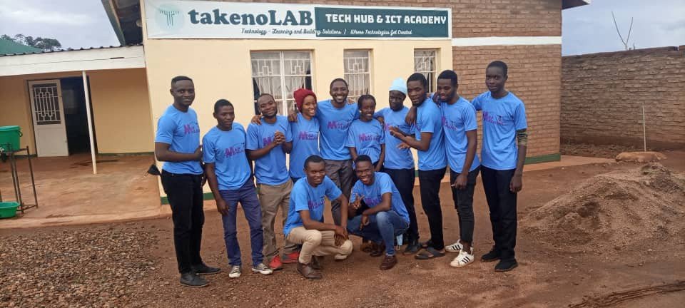
Community and youth involvement was at the heart of the project. Two youth-based groups are involved in the project. The first group consists of graduates from the African Drone and Data Academy (ADDA), who hold Bachelor’s Degrees from different Malawian universities. The second group consists of young people that live within and around the refugee camp and are affiliated with a local tech lab called TakenoLab.The goal behind youth involvement was to strengthen their technological capabilities and encourage young professionals to use geospatial technology to creatively address problems in their communities.

We strongly believe that involving community members, particularly the youth, in projects empowers them. It allows their voices to be heard, their knowledge to be shared, and their reality painted from their perspective. We believe that community involvement allowed the youth at the refugee camp to see themselves in the maps to be created. In addition, the youth at the refugee camp expressed that the project has motivated them to use geospatial technologies to highlight issues in their communities like electrification and the need for marketplaces.
One of the tools we used in our digitising process was iD Editor. We trained 46 people from the two youth-based groups on how to contribute to OpenStreetMap using iD Editor. To collect geospatial data for water points, dumping sites, education centres and hospitals, a survey was deployed using kobocollect. In addition, we trained two individuals from the Dzaleka refugee camp on how to collect geospatial data using the Kobocollect tool. After this data was collected, it was cleaned and uploaded to OpenStreetMap.
One of the most important lessons that we’ve learnt is how Community involvement and partnerships are critical to a project’s success. TakenoLab, our local partner at the Dzaleka refugee camp, helped us mobilise eager and willing youth to contribute and be part of the project. This group of volunteers was key to the project’s success as they were more knowledgeable of our study area and knew what kind of problems they encountered daily. The African Drone and Data Academy helped us acquire the necessary documentation for authorisation to fly from the homeland security ministry. The African OSM community significantly contributed to the project through edits, tip sharing and feedback. In addition, the Humanitarian OpenStreetMap Team (HOT) Data Interns validated the mapping for this project. With the assistance of these partners and communities, 11,687 new edits were created and validated under this project.
What’s next? As MapMalawi, we plan to continue to work with youth groups in different communities around the country. While putting communities on the map and highlighting their needs, we hope to contribute to youth empowerment and capacity building. Our journey has just begun, and we are still learning. We hope to collaborate with more mapping communities within and outside Malawi. In the words of Helen Keller, we believe that alone we can do so little; together, we can do so much.
Share
