Mapping Makoko Using Drones and Canoes
Posted by Anton Marshall • Jan. 4, 2021
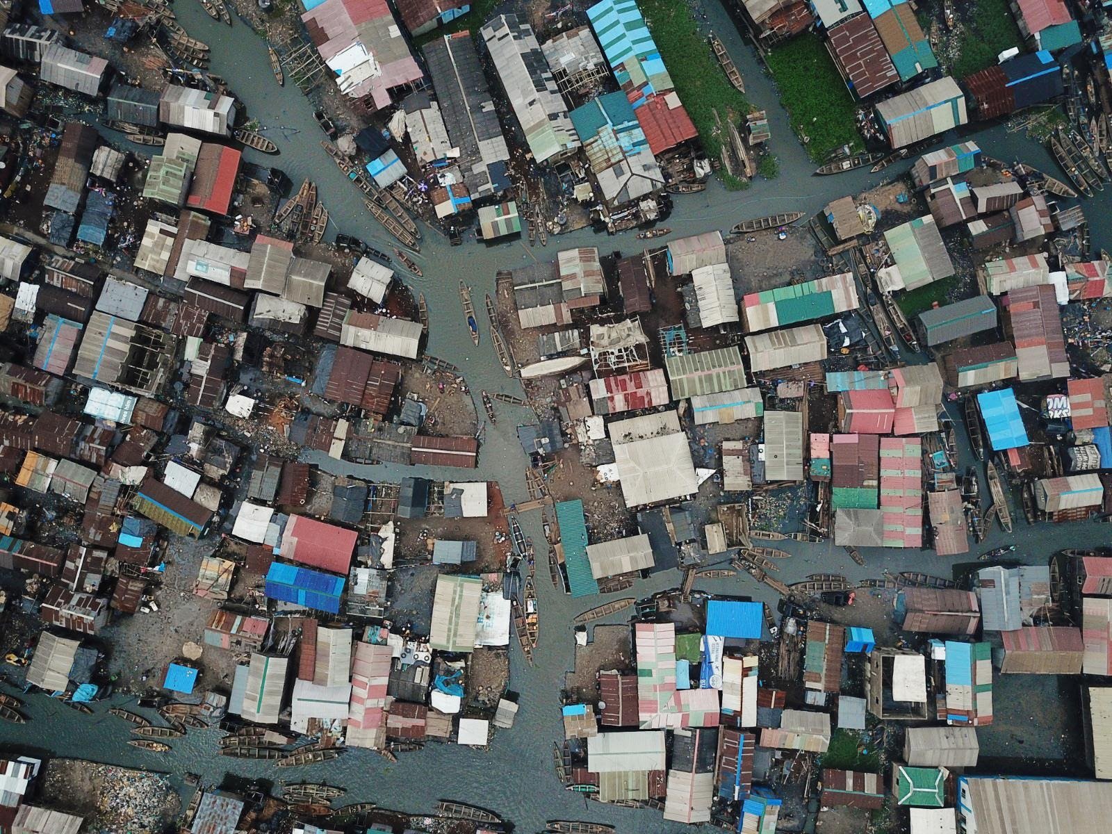
A floating inner-city slum is in the process of being mapped to make a case for improved public services and land ownership.
Ever mapped a city from a canoe before? Code for Africa, in partnership with Pulitzer Center on Crisis Reporting and the Humanitarian OpenStreetMap Team (HOT), enabled a team of volunteers to do exactly that in Makoko, a floating city in Lagos, Nigeria.
Makoko is one of Africa’s floating inner-city slums, with a third of the community built on stilts in a lagoon off the Lagos mainland. The rest of the settlement is on swampy land with little sanitation and few public services.
Makoko’s origins stem from a migrant fishing community from Togo and Benin, who settled there in the early 1900s. It is estimated that around 300,000 people live there today, but the lack of baseline data means the official population is unknown and largely politically unrecognized.
Makoko doesn’t feature much on current maps, and there is very little information on its geography, population density, or land ownership. The team started from the assumption that an accurate map is fundamental to plan and improve the living conditions of those who live in Makoko. An accurate map of the area works as a tool for advocacy: local communities and authorities can refer to the map to make participatory decisions around the development of Makoko.
But recently, a number of community members received training to use the latest available tech to actually map Makoko. The team - which included women from the local community - uses OpenStreetMap to draft a layout of the area complete with landmarks and ‘streets.’
Much of the project and training was managed by Jacopo Ottaviani and John Eromosele (from Code for Africa) with the participation of Khadija Ali and Fredrick Mbuya (Uhurulabs / AfricanDRONE), Dennis Irorere (YouthMappers), Emmanuel Agunze (Makoko Dream), and Nigerian drone pilot Ayo Akinseye. It encompassed subjects like drones for land survey, data acquisition using drones, drone piloting, and navigation systems. Special components also included primary data collection using technology and community building and OpenStreetMap.
MapMakoko - as part of a collaboration with the Pulitzer Center on Crisis Reporting - has also been featured on a number of international media outlets, such as CNN Africa, Al Jazeera, France24, and the BBC.
As recently as 2012, the Nigerian government attempted to remove the people of Makoko to clear the area and develop infrastructures. The inhabitants got worried about displacement and reacted against the government plans to clear the area. As explained by CNN Africa, “in recent years, authorities in Nigeria have embarked on mass demolitions of prime waterfront slums citing safety and security concerns. Rights activists, who fiercely oppose the decision, say the evictions are carried out often to appease property developers and to create luxury urban dwellings.” By mapping Makoko, residents may be able to claim a geographical status and hopefully demand access to basic services from the government, which are accessible to any other community.
Starting the project was not without its challenges. Team leaders needed to secure support from the community, who reflected diverse socio-cultural backgrounds.
To introduce the MapMakoko project to community leaders, particularly in a time when the people have been exploited over the years “by unrecorded number of organizations/Individuals,” we had to build trust through a partnership with the Makoko Dream (An NGO with strong support for Education in the community), Organized a couple of town halls, trained local volunteers to champion drone missions and ground data collection. During the drone mission, a group of community youths approached the team to question our authority to operate, and when they found out it was their sisters flying the drone, they rather posed for a photo than disrupting our activities.
One thing is key in community-based projects as MapMakoko, despite getting the buy-in of the Community leaders (Elders and Youths), Involvement of locals from the community to take ownership can not be overemphasized as these are the pillars of sustainability.
There was also the physical navigation of the area. Residents move around on bulky canoes through densely populated residential and informal businesses. Communication also proved to be tricky in Makoko as many people speak Egun dialect, while only a few understand Yoruba and French.

But the project is important - not only to Makoko’s future, but potentially to other communities in similar situations. MapMakoko’s Local Project Lead John Eromosele explains: “MapMakoko to me is a pilot that is currently sprouting sister projects, driving conversations around land rights in Lagos, Nigeria.
The MapMakoko team from Nigeria has proposed a panel discussion alongside the MapKibera team from Kenya at the 2020 edition of HOTOSM Summit event and the State of the Map Conference in South Africa (a global event) on the topic. Now we can share challenges and strategic solutions across the African Continent.
For now, the mapping project has reached his first milestone in Makoko, creating the initial geographical data set as well as mapping key markers. The skills learned in the training will be used to maintain and expand the map using OpenStreetMap.
About Code for Africa
Code for Africa (CfA) is the continent’s largest federation of indigenous civic technology and open data laboratories with CfA labs in Kenya, Nigeria, South Africa, Tanzania and Uganda and a further five affiliate labs in Cameroon, Ethiopia, Ghana, Morocco and Sierra Leone and funded projects in a further 12 countries. CfA manages the $1m/year innovateAFRICA.fund and $500,000/year impactAFRICA.fund, as well as key digital democracy resources such as the openAFRICA.net data portal and the GotToVote.cc election toolkit. CfA primarily supports grassroots citizen organizations and the media to help liberate data and empower citizens, but also works with progressive government agencies to improve digital service delivery.
In addition to funding and technology support, CfA’s labs incubate a series of trendsetting initiatives including the PesaCheck fact-checking initiative in East Africa, the continental africanDRONE network, and the African Network of Centres for Investigative Reporting (ANCIR) that spearheaded Panama Papers probes across the continent. CfA is an initiative of the International Center for Journalists (ICFJ).
Share
