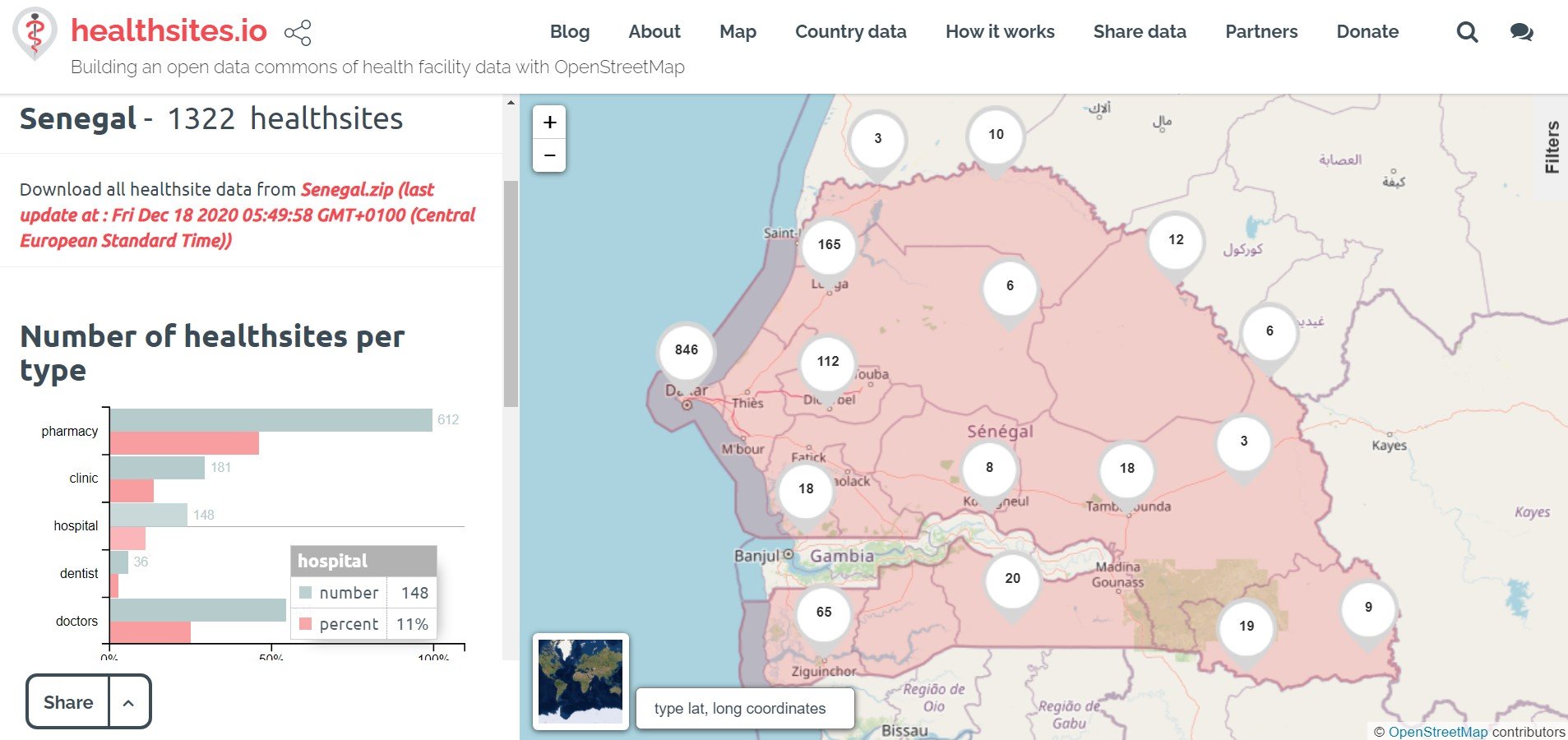
Mapping of Emergency Health Data in Senegal
Posted by Mohamet Lamine Ndiaye • April 19, 2021
With a microgrant from HOT, the OSM Senegal community and Healthsites.io have been mapping hospitals and clinics across Senegal, aiding in the country's Covid-19 response.
Since April 2019, Healthsites.io, in partnership with CartONG, Géomatica, and the OpenStreetMap Senegal community, has launched a series of activities with the aim of mapping health structures in Senegal.
Since April 2019, Healthsites.io, in partnership with CartONG, Géomatica, and the OpenStreetMap Senegal community, has launched a series of activities with the aim of mapping health structures in Senegal. The collaboration was possible due to the meeting held in 2017 at the Dakar Data Champion conference organized by the Dakar Humanitarian Data Exchange (HDX). Several team members, such as Mark Herringer from Healthsites and Labaly Touré from Géomatica, joined the discussion along with the OpenStreetMap Senegal community, who provided training on OpenStreetMap collaborative mapping techniques during a practical session.
 The OpenStreetMap Senegal team providing training by Heather Leson, CCBY4.0
To launch the pilot phase of the Healthsites project in Saint Louis, Senegal, Mark Herringer, the Project Lead at Healthsites, and Mohamet Lamine Ndiaye from the OpenStreetMap Senegal community conducted a series of meetings with stakeholders in the health cluster between 9 to 16 April 2019. In this week of advocacy, various meetings and working sessions were organized with all stakeholders in the health system in Senegal, including the Ministry of Health, non-governmental organizations, academics, and communities.
First, the team met with Daba Ndour, who is in charge of the health map at the ministry level, and Ibrahima Dia, from the Digital Health Unit of the Ministry of Health, to discuss the current projects and to analyze how the Healthsites.io project could add value to their work. Recommendations were made based on these conversations. To conclude the pilot phase, a meeting with the regional chief doctor of Saint Louis was also organized during the deployment of the pilot phase.
 Working session with Ibrahima Dia of the 'Digital Health Unit of the Ministry of Health and Daba Ndour GIS Manager at the Ministry of Health
These meetings aimed to create a synergy around the collaborative mapping of health structures between the communes of Saint Louis with support from the health authorities. The regional chief doctor Ndiaye’s presence during the closing workshop of the pilot phase was extremely beneficial.
 Photo with Madame Ndiaye during the closing workshop of the pilot phase of Saint Louis
Key Figures
-
10 investigators collected 104 establishments in 3 days
-
41 private / 58 public / 3 community / 1 NGO / 1 combination
-
24 open all the time
-
24 not wheelchair accessible
-
4 with solar electricity

The second week of the mission was then devoted to the presentation and promotion of our approach to local stakeholders. We conducted a workshop that was graciously hosted by OCHA and brought together several key organizations operating in Senegal, including PATH, MSF, AMREF, IntraHealth, and the Swiss Tropical and Public Health Institute, who provided a lot of detailed feedback to improve our approach. We then directly met individuals from several departments of the Ministry of Health in Dakar to discuss how to integrate our approach into existing operations and data management processes.
We were delighted to see that some of them saw the open data and crowdsourcing movement as an inevitable evolution that public actors should embrace and support by creating quality datasets for all.
 Workshop of health sites with stakeholders of the health cluster - Dakar July 23, 2019
Following the workshop, we met representatives of the GIS Unit of the Planning, Research, and eHealth Directorate of the Senegalese Ministry of Health in order to present the results of the pilot and discuss potential future collaborations. This session was followed by the first working session organized in April to present the project, followed by other exchanges and sharing of documents.
 Lamine Ndiaye presenting the work of OpenStreetMap Senegal to Dr. Youssoupha Ndiaye and his team from the Planning, Research and Statistics Directorate within the Senegalese Ministry of Health.
HOT Microgrant Success
With funding from the Humanitarian OpenStreetMap Team (HOT), the work of 2019 has been consolidated with a focus on emergency services on the national territory in response to the Covid-19 pandemic. When HOT announced its call for microgrants in early 2020, we jumped at the opportunity to bring together various members of our larger community to submit a proposal. We have thus received the wonderful news that our project is funded.

This is how the activities took place during the period from July 13 to December 08, 2020.
First, a training was organized for investigators on the approach and methodology of collection in accordance with the restrictions on movement in these times.
Following this training day, telephone calls were made to the various health structures on the basis of a contact list shared by the managers of the Statistics and Planning Department of the Senegalese Ministry of Health and Social Action.
Updating OpenStreetMap Data
Initially, we expected the Microgrant mapping team to update the data collected on OSM directly under their own name. This would have given each employee the opportunity to improve their own data collection statistics in the OSM and be a benchmark for the data.
However, due to the delay in the validation of the data, it was decided that Lamine Ndiaye, the OSM manager in Senegal, would update the data directly.
Thus, the tools of the OpenStreetMap ecosystem were used to upload the data into the database. The data was first transformed into the JSON format with the appropriate attributes with Kobotoolbox, then uploaded to OSM level so that it could be manually loaded into the OpenStreetMap database.
Validation with Stakeholders
For the validation phase, the cartographic managers of the COUS and the Path were consulted for a discussion on the angle of data analysis and the relevance of the attributes. In the end, Mr. Diatta (COUS) and Mr. Lankia (PATH) expressed their satisfaction with the work done by the community and assured their future collaboration to extend the project to the missing areas.
COUS Senegal
A data-sharing authorization letter has been officially shared with Dr. Bousso, director of the Senegal Health Emergency Operational Center. Although the data was not officially shared, we were able to constructively engage his team in a data validation process. Dr. Bousso congratulated Lamine Ndiaye and his team for their work. We look forward to continuing this relationship and sharing basic data from healthcare facilities with the OSM.
PATH Senegal
A data validation workshop was organized with PATH, which is a strong supporter of this work. The data collected and shared is used to support PATH's Partnership for Malaria Control and Elimination in Africa (MACEPA).
As part of this mapping project of emergency services in Senegal, the OpenStreetMap Senegal community, with the support of Healthsites.io, was able to add or update 104 structures across the country with 35 new structures added to the OpenStreetMap database and 79 structures with updated attributes.
-
104 structures added or updated
-
35 new hospitals added to the OSM
-
79 hospital attributes modified
-
5 clinics
-
63 Doctors
-
35 Hospitals
-
1 Pharmacy
-
Of the 104 establishments, 39 had an ultrasound service
-
Out of the 104 establishments, 49 had an emergency service
-
Out of the 104 installations, 25 were equipped with X-ray machines
-
Of the 104 establishments, 41 had imaging equipment
-
Of the 104 establishments, 30 had an operating room
-
Of the 104 installations, 65 had a laboratory
-
Of the 104 establishments, 80 had an operating room childbirth
An interactive map of the data is available here.
Social Impact
OpenstreetMap's Cartographers OpenStreetMap cartographers are able to build on this work and further develop the user stories that are important to them.
Senegalese Ministry of Health (COUS) The data collected has been made available to the Ministry of Health. The team has established a relationship and plans to further engage in supporting emergency health and the COVID-19 COVAX response.
Senegalese Citizens The availability of data in health facilities allows decision-makers to better meet the needs of the Senegalese population. The data is used by humanitarian aid organizations to identify gaps and pressure points experienced by the COVID-19 COVAX response. This will make it possible to optimize the use of donor funds by prioritizing needs on the basis of available data.
Healthcare Practitioners Data allows healthcare practitioners to get a clear picture of the state of the healthcare system and to identify gaps that can put people's lives at risk. The data can be used by health practitioners to influence the needs of decision-makers.
Public Health Service Providers The availability of data on health care facilities in the region enables public health service providers to plan responses and campaigns regarding the COVID-19 outbreak. Once vaccines are available, this information will be essential in setting up a vaccination strategy.
Social Entrepreneurs Entrepreneurs and civil society can use the data to develop innovative solutions related to COVID-19, as has happened elsewhere in the world.
Healthcare Industry Data can be used by the healthcare industry to streamline supply chains or identify opportunities for innovation.
Stories from Emergency Health Workers and Citizens
Epidemiologist
As an epidemiologist, I want to know the number of hospital beds in a health facility so that I can assess the capacity to manage an epidemic.


Citizen
As a citizen intervening in a road accident, I want to know where the nearest emergency service is so that I can lead the person I am helping to the right place.

Pregnant Mother
As a pregnant mother preparing for the delivery, I would like to go to an ultrasound facility so that I can give my baby the best possible care.
More stories from stakeholders can be read here.
Contact us if you wish to launch a health emergency mapping campaign
Share
