Open Geospatial Data in Environmental Management: Context, Opportunities and Challenges
Posted by EMMANUEL NIKOYO EMOUGOU YVES • June 28, 2022
The webinar was organized by the Humanitarian open mapping Community Working Group. It showcased initiatives that use open source geospatial data for environmental management issues. Forestry, protected areas, reforestation, species inventories and large mammal monitoring were the themes.
 Session in English
 Session in French
Using Open Source Geospatial Data in Environmental Management
Open source data provides innovative solutions to environmental issues. For example, open data is used to mark deforestation that leads to the destruction of large mammal habitats and migration of species. Tools such as Global Forest Watch, an interactive online forest monitoring and alert system, are designed to manage and conserve forest landscapes. This free and easy-to-use tool allows users to produce customized maps and analyze forest trends.
 GFW interface and alert system
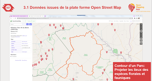
For protected areas, the opportunities for using open data are quite varied. Open data provides insight into the delineation of protected areas, buffer zones and community zones to limit infringement. It also provides an overview of land cover, topographic features , different localities and administrative divisions facilitating easy decision making. The data promotes ecotourism by facilitating the planning of excursions around the protected areas. For example, The Mapati project used open data in mapping trees in urban space to assess the impact of heat islands in cities and to implement a reforestation policy.
Applications to address environmental issues
The webinar highlighted the importance of OSM in environmental management. OSM data includes protected area boundaries and surrounding infrastructure, land use and tree mapping.

.png) Information representation in open source applications
Information representation in open source applications
The USGS site offers satellite images accessible to all to facilitate environmental monitoring over given periods.
.png) Image from the USGS site: evolution of the surface of Lake Chad
Image from the USGS site: evolution of the surface of Lake Chad
Applications such as KOBO collect Tool, Street Complete, Osmand are used to support the collection of data on various environmental themes.
.png) The applications used for the acquisition of free geospatial data
The applications used for the acquisition of free geospatial data
The use of free geospatial data and open source tools is important for environmental issues. Training communities is essential for reliable results. OSM features free data that can be modified by all. Therefore it is important that each community and organization has a dedicated team, controlling the data and its quality. The involvement of various actors, using new technologies in implementing open data in geographical projects is vital.
Share
