Paving the Road to Inclusivity, HOT Trains Mapping Skills to Disabled Communities
Posted by Biondi Sanda Sima • April 25, 2017

Supriyadi, 60, lost his ability to walk 11 years ago when a magnitude of 5.9 earthquake shook Yogyakarta, one of Indonesia’s provincial capital. It took almost one year for his upper body to physically recover from the incident and he may never fully recover from the fact that the earthquake took his second child; among the over 5,700 death toll in that day. Supriyadi has to travel by a wheelchair from that moment on.

Pic 1. Supriyadi assisted by a caregiver to climb an ascending road during a field survey training on disaster contingency planning and data collection using OpenStreetMap.\
There are numerous reasons how someone may turn into a person living with disability (PWDs). Natural disaster is one of them. In addition, when a disaster hit, PWDs are among those who are disproportionately affected. PWDs’ physical barriers may prevent them from easily evacuating themselves without assistance.
According to the Living with Disability and Disaster Survey by UNISDR (2014), only 20% of 5,717 worldwide PWD respondents say they could evacuate without difficulty in the event of disaster. Despite of the greater number of casualties from PWD communities, 85.57% respondents say they have never been involved in disaster preparedness and response activity.
3 in every 20 people in the world suffered from some form of impairment. In Indonesia alone, there are over 37 million people who have disabilities, either by birth or are acquired due to accident and/or disaster. Due to minimum opportunity and provision, about a quarter of persons of disability in Indonesia live in extreme poverty.
In recent years, humanitarian organizations are trying to put a dent in the livelihood of PWDs by taking on inclusive approach in every stage of preparedness and response activities. Improving information infrastructure that can enable PWDs to fully participate and contribute, as well as be properly informed and communicate for assistance in the event of disaster.
This is in line with many international umbrellas, such as UN CRPD (Convention on the Rights of Persons with Disabilities), Sendai Framework, and the Sustainable Development Goals. The Convention specifically outline the following, “States Parties shall take, in accordance with their obligations under international law, including international humanitarian law and international human rights law, all necessary measures to ensure the protection and safety of persons with disabilities in situations of risk, including situations of armed conflict, humanitarian emergencies and the occurrence of natural disasters.” Treating inclusivity a rights-based approach, instead of mere affirmative action is also something that needs to be proactively mainstreamed in development programme. The implementation of these frameworks, however, remains to be a great challenge.
Workshop on Open-source Technology
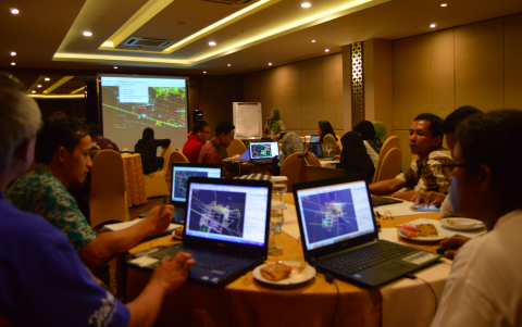
Improving the livelihood of the most vulnerable communities through capacity development using open-source technology, Humanitarian OpenStreetMap Team (HOT) and Disaster Management Innovation (DMI)--with the support from Australian Government--collaborated with Arbeiter-Samariter-Bund (ASB) Indonesia and the Philippines with the support of USAID and Badan Nasional Penanggulangan Bencana (BNPB). HOT delivered a technical training over the weekend on how disabled communities can leverage their position by mapping their community’s location and relevant points of interest needed for humanitarian coordination when an emergency situation occurs.
Pic 2. Supriyadi and his fellow communities of PWDs are trained to trace satelite imagery to inform accessibility of their surrounding areas.\
Training is tailored specific to the needs of PWD by teaching them the use of innovative, open-source tools, such as WheelMap and OSM Tracker as well as GPS, JOSM, and InaSAFE that enable them to initiate data collection and perform a GIS analysis of the risk in their surrounding neighborhood. Taking place in Solo and Desa Gadingan, participants trained in both classroom setting and on-field survey.
Wheelmap is a web-based and mobile application that can help identify whether a public facility is fully, partially, or not accessible for people traveling with wheelchairs. Tagging in wheelmap is very straightforward, allowing people in general including PWD communities to easily add information on it through simple three-color coding.
There are still several limitations on applications, such as wheelmap, and other map related tools. Being a visual tool to inform disaster managers and policy-makers on making infrastructure accessible, PWDs especially those with visual impairment may not be able to fully utilize the application features. Further enhancing voice assistant (talk back) on most features will greatly improve its accessibility for the blind. During the training, the role of a caregiver is also indispensable. HOT had also developed map tagging, such as tactile pedestrian access, in addition to wheelchair access for people like Supriyadi to identify and inform the overall distribution of infrastructures accessible by PWDs. Having a tactile map printed out for community members with visual impairment will also help them able to identify their location and its adjacent facilities, allowing them to be situationally aware of their neighbourhood and orient when an unfortunate event strikes.
The following is a video documentation of this training. As seen from their testimonies, we are grateful that our participants found the training useful as it equips them with necesarry skills and it has motivated them to play active roles in promoting inclusive and resilient communities.
Share
