Amazonian Mapping for an Inclusive and Sustainable Amazon
Posted by Fabrizio Scrollini • Feb. 12, 2024

Explore the Amazonian Mapping initiative, a project by the Open Mapping Hub focused on Latin America, highlighting the importance of social impact mapping in the Amazon region. Discover key projects in Colombia, Ecuador, Brazil, and Peru to strengthen prevention, emergency management, sustainable forest management, and community resilience.
Few things represent a region as iconically as the Amazon: eight countries share the care of an area where 20% of the world's freshwater reserves are found. The diversity, richness, and development potential of this region are a source of hope for the communities that inhabit it, as well as a source of conflicts and challenges common to the region and the world. Here, we face situations that jeopardize biodiversity, subsistence, and the security of local communities. Deforestation, climate change, and economic pressures have created a complex landscape that demands understanding and action.
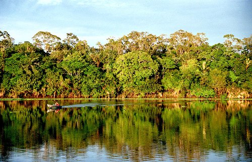
Amazon rainforest on the Urubu river, Amazonas State, Brazil. Licensed under the Creative Commons Attribution 2.0 Generic license.
It is crucial to recognize that the preservation, restoration, and sustainability of the Amazon region are not only vital for Latin America but also represent a critical challenge on a global scale in the fight against climate change. The Amazon is home to communities whose survival is closely linked to the rainforest. The forest is an integrated ecosystem, and humans are part of it, with their activity capable of either promoting sustainable development worldwide or contributing to its disappearance.
In this context, the social impact mapping initiative, "Amazonian Mapping," by the Latin America and Caribbean Open Mapping Hub (LAC Hub), seeks to map built elements, land use, and critical environmental conditions in the OpenStreetMap (OSM) free and open-source cartographic database. This allows local actors and specialists to use this information to understand risks and impacts and implement organized actions in their territory.
Maps are alive, like the territories of the jungle and its population. For example, the communities living along the Solimões River systematically move due to their way of life, landslides, and potential threats from land grabbers. These communities face difficult situations that require the assistance of Civil Defense, among other actors, who require precise geographic information.
To address the "cartographic void," especially regarding the distribution of these populations and the threats they face, we are working. Therefore, the initiative will promote knowledge exchange and technical training in mapping and spatial data use among communities and various actors committed to the preservation and sustainability of the Amazon. Detailed and comprehensive cartography of the region will expand visibility and facilitate access to all information for the Amazon defense sector.
On the occasion of the International Day of the Amazon, on February 12, we launched the "Amazonian Mapping" initiative, aimed to close the cartographic gap in the region, promoting the use of mapping for social impact in service of the region. This initiative began on that symbolic day, but its focus is long-term. We start with projects focused on identified needs of communities and governments as a starting point to continue mapping the entire region later on.
Get to Know Our Amazonian Mapping Projects
Flood Risk Monitoring in Tefe, Brazil
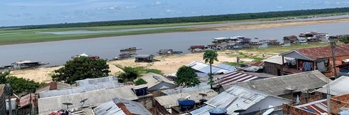
Tefe is one of the last inhabited cities on the borders of the Brazilian Amazon. The municipality is not accessible by land, and difficult access is compounded by other challenges such as extreme poverty, exclusion of public services from its indigenous population, and the challenges posed by the impact of climate change. Much of the community living around Tefe is not represented on maps, and therefore authorities cannot reach them. Additionally, erosion caused by private deforestation is a critical problem requiring constant monitoring.
In our work in Tefe (still ongoing), we are exploring three ways of working with the community in this region: training for inclusion, innovation, and use of maps by local authorities.
On one hand, we are training students from two communities: Alvarães, Nogueira, and San Luis de Macarí, to create specific projects using our Tasking Manager system and drone image data. This was done in collaboration with the Federal University of São João del-Rei, the State University of Amazonas (UEA), and the Civil Defense of Tefe, who received remote training from representatives of Canoa de Tolda, another of our projects in Brazil. During 10 days of field activities in November 2023, specific data was collected and processed using drones in communities not represented on official maps.
The Tefe community adopted manuals and guidelines to their local context, using previous knowledge from similar projects implemented in 2022. Finally, the community, through the project, is responsible for monitoring dynamics in the mapped communities and assessing the possibility of replicating the process in other areas, such as in the Middle Solimões, which will significantly contribute to the representation of cartographic data and access in the Tefe region. We are working on expanding these trainings, which will allow us to expand our work in the region and reach more territories and people.
On the other hand, teams from the Federal University of São João del-Rei and UEA developed technology that allows obtaining high-quality geographic information using systems that do not depend on internet connection and drones. This information can then be uploaded to OSM and, consequently, improve the quality of maps globally.
Collaborative and Inclusive Mapping in the Middle Solimões, Brazil

Researchers from the Federal University of São João del-Rei, the Center for Higher Studies of Tefe, and the LAC Hub are working to complete maps of the Amazon region by using the OpenStreetMap (OSM) platform and training local communities in affordable technologies to monitor climate change.
Our strategy includes seminars, workshops, field data collection, and drone flights, all aimed at capturing high-resolution images and collecting data to improve the representation of the Middle Solimões on maps.
We emphasize local commitment and collaboration as fundamental pillars to address cartographic challenges in the Brazilian Amazon. In addition to filling gaps in maps, we seek to strengthen local communities, preserve cultural and environmental diversity, and contribute to sustainable development in the region. Our approach involves processing and analyzing the collected data, updating OSM, and disseminating results to inspire similar initiatives in other regions of the Amazon and globally.
Training of indigenous educators in open mapping, Pucallpa, Peru

The environmental issue is of great importance in the area and especially for indigenous communities, who see their ancestral territories threatened by deforestation resulting from illegal logging and also by pollution from various sources that makes the rivers and lakes that provide them with water and food unhealthy.
In Pucallpa, Peru, we are laying the groundwork for a group of local educators from indigenous communities. This group, in collaboration with the National Intercultural University of the Amazon (UNIA) and local organizations working for the preservation of the Amazon forest and the sustainable economy of forest communities, will support environmental monitoring through community mapping.
Mapping as a tool for risk management in the Ecuadorian Amazon

Much of the social and economic infrastructure of the Ecuadorian Amazon - which covers an area of approximately 120,000 km2, 956,000 inhabitants and represents almost half of the surface area of Ecuador - is invisible on the OSM map and few data on this region are available on official cartography.
Our initiative in the Ecuadorian Amazon, with the support of OpenLabEc, trains communities in disaster risk mapping using OSM and Mapillary. In this way, we will strengthen risk management efforts in Amazonian cities such as Nueva Loja, Tena, Puyo and Macas, through the creation of new communities of mappers in collaboration with local risk management secretariats and civil society organizations.
Advancing our Partnerships with Civil Protection

In Latin America, we have a variety of networks and actors dedicated to risk management. Our goal is to consolidate our position as a reliable actor in improving information for risk and disaster management throughout the region and progressively mapping vulnerable areas, filling the gaps in available official cartography. This information will be key for these organizations, and its use is part of our core objectives.
In this regard, we are interested in strengthening our relationships with local allies and municipal Civil Defense departments, as we have done in our projects in Tefe, Brazil. Likewise, we seek to establish links with national civil protection and disaster risk management authorities in projects addressing a regional perspective of the Amazon, in Ecuador, Brazil, and Colombia, as well as in other projects in Mexico.
This is a continuous and systematic effort that will allow us to provide more effective, anticipatory, and community-focused responses to the challenges presented by risk management in Latin America. We do not adopt a one-off strategy but establish connections throughout the region individually and systematically. We are committed to working together to ensure the safety and well-being of our communities throughout the region.
Anticipatory Mapping of Risk Areas in the Amazon

In coordination with the authorities responsible for risk management in Ecuador, Colombia, and Brazil, we have identified the most vulnerable areas in the first quarter of 2024 for these countries, many of which are related to extreme droughts caused by the El Niño phenomenon in forested areas. Therefore, we have launched mapping projects on the HOT Tasking Manager.
On the occasion of the International Day of the Amazon, on February 11, 2024, we invite the general mapping community to participate in these projects by exploring those published on the Tasking Manager with the tag #mapeo_amazonico. It is a call to action to contribute to these projects that are vital for risk preparedness.
Join us for a resilient and inclusive Amazon! Your contribution is crucial to prepare for the challenges facing this invaluable region.
Tasking Manager Campaign: Mapeos Amazónicos
Projects Brazil:
Projects Colombia:
Projects Ecuador:
Our strategy for the next two years is to prioritize mapping of the most vulnerable areas and communities, progressively advancing to complete a comprehensive map of the region. This map will be a powerful tool for all communities and decision-makers, providing detailed information that will enable better planning and response to risk situations.
In addition to detailed mapping of populated areas on the Tasking Manager, we have opened a series of projects on mobile applications like MapSwipe. These projects involve large communities of mappers for monitoring the jungle and the interventions that can be observed, such as deforested, cultivated, or otherwise exploited areas.
We invite anyone who wants to contribute to mapping from their cell phone in their free time to install the MapSwipe application and search for Amazonian projects there.
Community Projects in Development
In addition to remote mapping of the Amazon carried out by global OSM communities in collaboration with other organizations, we are conducting several community projects with local allies.
Our goal is to teach cartography to rural and indigenous communities in the Amazon, as well as university groups and civil society in Amazonian cities. We will work with these groups to build maps tailored to their territorial management needs.
During 2024, HOT will develop a grant in collaboration with Meninas da GEO, a group of female mappers from the Federal Institute of Pará (IFPA) and the Federal Rural University of the Amazon (UFRA). The aim will be to map the quilombola region of Moju along with the Perpetuar Project. Local communities have expressed the need for maps reflecting their interests and needs, such as mitigating the impacts of two major projects developed by private organizations, environmental racism, and the climate crisis experienced in their territories.
If your organization is part of this sector or is a community organization in the Amazon working on territorial management issues, contact us!
Our Long-Term Vision
This is the beginning of our systematic work in the Amazon, based on the premise that communities can use geographic data to improve their living conditions, preserve their environment, and protect their rights. To access this data, communities need to have the right capabilities, innovate in how they use tools designed for other contexts, and use these tools sustainably. OSM, a true digital public good, can be used for these purposes.
We seek to develop flexible methodologies to enable the populations of this diverse, rich, and unequal region to know their own territory and use this information to live resiliently and sustainably in it. It is a long-term task, in a complex region, and we will not do it alone. We believe in and seek the cooperation of all public, private, and international organizations that believe in the power of open data to contribute to the protection and development of one of the most emblematic and important areas of our region.
Share
