Canoa de Tolda: Representing the social dynamics of the São Francisco River through mapping
Posted by Juan Arellano Valdivia • Aug. 30, 2022
Early results of HOT's collaboration with Canoa de Tolda to make the social dynamics of the São Francisco River visible through open mapping and the use of drones and other technologies.
What is Canoa de Tolda?
Canoa de Tolda is a Brazilian organization created in 1998, which currently works in the lower stretch of the San Francisco River, in the states of Alagoas and Sergipe, collecting information on social, cultural, scientific and environmental issues in the region impacted by the dam of Sobradinho.

Partnership with HOT
Since November 2021, in partnership with HOT, Canoa de Tolda has been developing collaborative mapping exercises using open tools, with the aim of producing data for monitoring hydrological and environmental conditions that do not exist on official maps, in order to empower civil society in open data management, and improve community-led disaster risk reduction plans.
Marina Aragão, HOT coordinator for the project, believes that the partnership initiative “has been a unique interaction between international relations, global and accessible technology and the empowerment of local populations, and represented a pioneering and challenging opportunity, especially considering the analysis of a river that has an enormous representation for the Northeast region and for Brazil”. (Source).
.jpg)
Progress to date
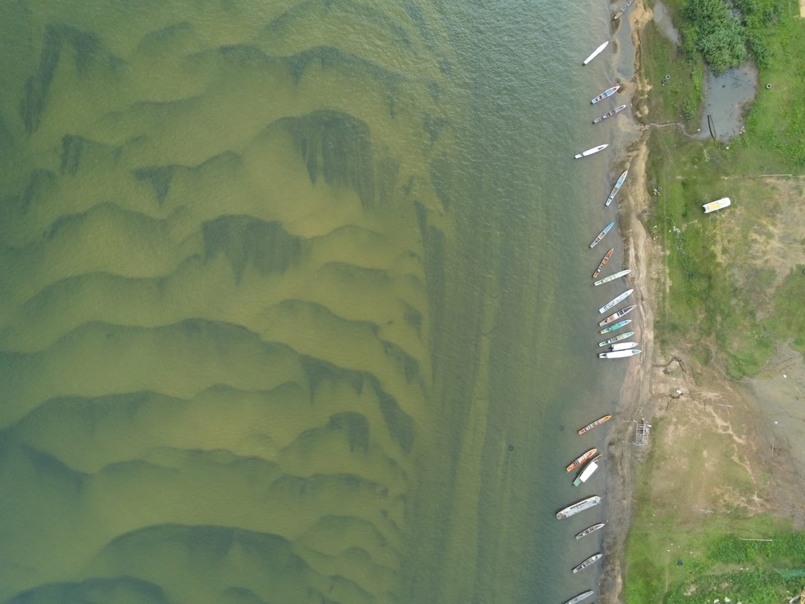
Between June 27 and July 8, 2022, HOT trained the Canoa de Tolda team by sending a team of experts and supporting the acquisition of materials and equipment for the development of the organization's different activities: flood monitoring, 3D drone modeling and community mapping. This was done in the city of Ilha do Ferro, taking into account that it has a considerable population at risk. In the future, Canoa will be able to reproduce the process in other parts of the river.
As Carlos Eduardo Ribeiro Jr, from Canoa de Tolda, one of the creators of MapSãoFrancisco, explains, [the area of]– Ilha do Ferro, "being not so extensive and close to the base, allows the application of the techniques transmitted [to the team] to the various situations of the flood plain: urban agglomeration, occupied and unoccupied marginal lagoons, two river channels. This variety of cases will allow us to train and improve our capacity for the evolution of the project throughout the Lower São Francisco”. (Source).
+(1).jpeg)
Activities
-
Preparation of equipment purchased through the alliance with HOT (drones, batteries, fishfinders)
-
River tours in speedboats with depth and flow measurement in key areas; fluvial bathymetry tests.
-
GPS measurement of terrain points in high and dry areas near the river and installation of land control points in strategic parts.
-
Installation of a base for the GNSS (Global Navigation Satellite System) in the highest part of the city, and construction of a polystyrene foam base for the navigation of the fishfinder and GPS in the river.
-
Flights and aerial shots using drones.
-
Community meetings to listen to the perception of river management and alternatives for disseminating the work carried out.
-
Community training meetings in the management of purchased equipment, software and applications.
-
Consultations with the university.
.jpg)
“We had a situation right at the beginning of the activities that required a quick solution: how to use the sonar to attend the training, not only on those days, but also in future bathymetry activities.[...] It was then that we decided to build a small non-motorized trimaran -of foam- that would receive the necessary sweeping equipment. The trimaran would be towed by one of the speedboats that carry out the activities, which is nothing new, since numerous aquatic prospecting systems use similar small boats”, explains Carlos Eduardo. Collectively built by the participants of the activities in a few hours, the trimaran demonstrated, in the water, that its association with the proposed equipment was correct: the quality of the data obtained was extremely favorable, of great precision, all obtained in a short scanning time. (Source).
According to Ivan Gayton, HOT Humanitarian Advisor and one of the coordinators of the cooperation with MapSãoFrancisco: “Canoa de Tolda brought a great novelty to the table; Prior to this project, our bathymetric surveys were conducted with a pole-mounted GNSS receiver by a river surveyor dressed in waterproof clothing. This was out of the question for a river the size of the São Francisco, so the team selected a consumer sonar unit (a fish finder!) to measure depth, intending to keep this unit in the water from a small boat. However, Canoa de Tolda built a small custom foam trimaran, with the high-precision GPS unit mounted on top and the sonar on the bottom. This worked very well, not only allowing for otherwise difficult and dangerous bathymetry surveys, but also making the whole process much faster and more efficient.” (Source).
.jpg)
Challenges and learnings
The Canoa de Tolda project highlighted the strength of spaces for discussion between communities. Canoa came to HOT through an OpenMap Development Tanzania (OMDTZ) webinar , which made them understand that their context in Brazil had many similarities to the context presented in Tanzania, and that the low-cost methodologies and techniques adopted could be used by Canoa. This makes important strengthening such spaces through events and communication materials.
The monitoring process described demonstrated the importance of generating data for the communities, since this results in consolidated information that has a positive impact on the economic dynamics of the area (case identified in the community of Ilha do Ferro, which is dedicated to tourist and craft activities). The data produced with the support of HOT will allow Canoa de Tolda and the local community in general to be independent of access to accurate and real information on the volume of the river, since currently such data is owned by private companies and state agencies. This dynamic will allow them to fight for flood risk mitigation plans, in addition to other public policies related to the issue, such as urban planning, access to health, etc.
The communities are interested in these types of issues, so there is a favorable scenario for their development. On Ilha do Ferro, there is a great interest in more open and community mapping activities. Most of the territory is not adequately represented on maps, which directly impacts the population's lack of access to basic public services, in addition to its economic activity. However, the training of the communities in mapping tools and methods must take into account the language, which must be in accordance with the literacy levels of the communities, the challenge being to make the technical language available to all.
+(1).jpeg)
Among the risks identified in the project are: the rainy season can limit the development of activities and/or tours of the riverbed. The need to have first aid elements in the communities was identified, minimizing risks in the transfers for the development of activities; have a satellite phone to guarantee permanent communication; and have cell phones with the latest Android system for compatibility with applications and technical software.
A further goal is for the experience to benefit more communities in the region. The local people responsible for the project will present the applied approach and the results obtained in various spaces, which is sure to be of interest to the open mapping and drone community."
The expressions of all the participants at the end of the training are a testimony of satisfaction with the experience, its results and future perspectives, as Marina Aragão, project manager, expresses when she says that “it is a long road that we have only just begun. From the point of view of open and participatory mapping, we understand the need to encourage community participation in this process. It is very important to think of long-term educational projects, mainly aimed at young people, that serve as an ecosystem for social transformation and technological inclusion”. “HOT's support, with the transfer of tools and technical knowledge, will surely pave the way for more assertive discussions about the reality of the populations that live and depend on the São Francisco River, in addition to having demonstrated the local potential for the production of innovative technologies.” Marina concludes. (Source).
Share
