News — 10 June, 2025
Humanitarian GIS Reflections in Mid-2025: A Collaborative Approach to Geospatial Data

Amid severe funding cuts in 2025, humanitarian GIS practitioners are prioritizing collaboration to avoid duplication and leverage shared resources like OSM. Spatial data—particularly OSM’s open, community-driven model—offers a resilient framework for coordinated crisis response, combining local knowledge with global standards.
The first Humanitarian Networks & Partnerships Weeks (HNPW) I attended in person was in May 2022, when we were coming out of the pandemic. At the time, I felt an energy in the room - a sense that genuine collaboration between organizations was finally within reach after so long living in digital spaces. As excited as we all were to be back in person in our offices and at conferences, there was a clear interest in continuing a remote but connected way of working.
Three years later, in 2025, that excitement to work together is being quickly prompted into reality as we find ourselves in a very different sector with massive funding cuts. Attending this year’s HNPW in March, these were some of the themes that came up repeatedly throughout the conference:
- Stopping duplication through increased coordination
- Improved working with local actors
- Co-funding is the future
Watching the life-impacting USAID and donor cuts is devastating (I encourage you to check out ACAP’s series on the cuts for numbers on the toll this is taking for those in need). Watching colleagues who did good work get laid off is disheartening. And, data has been some of the first things targeted in cuts, as they are not seen as “essential”, leading some to say we are going back years in how we as an international community respond to humanitarian crises. (Humanitarian data drought: The deeper damage wrought by US aid cuts).
Is it inevitable that we go back to uninformed responses? While the above is true in a lot of ways, I think the progress to date in conducting informed responses will help those left in the sector not to start from scratch. And, I believe spatial data can lead the way. Maps have always brought people together. Maps of common infrastructure or relevant spatial trends (climate factors, market prices, security, etc.) are information that most humanitarian actors would find useful, or need. Humanitarians are often already looking at the same information as each other on different maps. As the making of maps is already always a team effort, bringing together different areas of expertise, how can we best leverage this process to scale collaboration as a sector?
OpenStreetMap (OSM), HOT’s core system of use, is one of the best examples of a shared resource. At OSM’s heart is data sharing: whatever data goes into OSM, anybody in the world can use. No other spatial data system like it exists, which is why it has grown into the go-to data source for many spatial data layers worldwide.
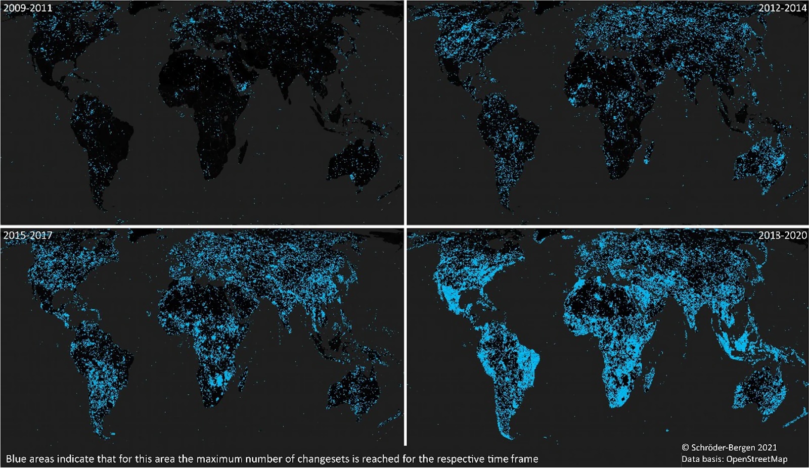
OSM’s value as a widely shared resource in humanitarian contexts is also demonstrated by its high activity on the Humanitarian Data Exchange (HDX). Almost 5,000 users visited OpenStreetMap exports by HOT on HDX in the last 30 days, and OSM is commonly cited as a recommended data source in HDX’s Data Grids.
In addition to OSM’s data platform, the community around OSM is a great example of locally led systems with a connection to global support. Locally, people tend to map what is around them, leading to thousands of local OSM contributors and locally based OSM groups who keep in touch through various channels and events. Globally, the OSM wiki, OSM Community Forum, and other networking support global data creation and best practices. This process demonstrates OSM as a grassroots system with the ability to customize global best practices for a local context. Recent examples include growing OSM communities in Sudan and Lebanon.
Besides OSM, there are existing systems we are already using to collaborate. Other non-OSM data sharing is made easy through the Humanitarian Data Exchange (HDX). Coordination is made easy through virtual events and groups such as HNPW, but also the Global Information Management Working Group (IMWG) for GIS. At last year’s HNPW, the IMWG GIS identified data sharing and ensuring we are meeting core data standards were already priorities we can continue. In that spirit, I suggest all of us working in geospatial data in the sector:
- Come to an understanding about the core spatial data layers needed in a humanitarian context that multiple organizations will need. We can start with the spatial datasets in HDX’s data grids, and also consider the top downloaded OSM datasets: roads, waterways, building footprints, populated places, health facilities, and schools.
- Share with others if you have information on any of the above datasets in a humanitarian context. Or, be vocal in shared networking spaces if you are looking for a dataset to find others to work together with.
- Find partners: Spend the time to work with those outside of your organization to identify similar project overlaps and synergies.
Some examples of recently HOT-improved datasets of shared need when instigated by a partner in our Program on Conflict and Displacement:
- Updated building footprints in OSM areas of high displacement in Somalia
- Building footprints in OSM in Gaza
- Mapped heritage sites in OSM in Lebanon and Sudan
- Mapped logistics data in Sudan
- Improved data quality in parsing English and Arabic road names in Sudan
⠀ Would you like to partner with us? We’d love to hear from you! Reach out at data@hotosm.org. If you haven’t already, consider joining the Global IMWG for GIS - a collaborative group chaired by members across multiple organizations. It’s open to anyone interested in humanitarian GIS. You can sign up for monthly calendar invites and (very few) emails here and get info about our Slack channel here. It’s never been a better time to stay in touch.