Mapping Cholets, or how to build a mapping community in El Alto, Bolivia
Posted by Juan Arellano Valdivia • July 27, 2025
Explore how mapping cholets in El Alto brought together community, culture, and open data—using ChatMap, to showcase a unique urban identity.
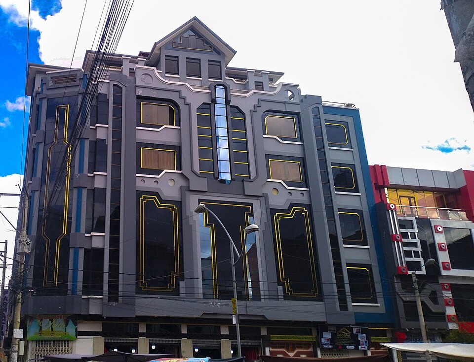
Do You Know What a Cholet Is? When we set out to map cholets in El Alto, La Paz, as a side event to AbreLatam/Condatos, the largest open data gathering in the region, held in July 2025, we thought we knew what a cholet was. Now, we not only know what they are, but also what they mean and how they are part of the social fabric of this vibrant city.

Before diving in, let me tell you the story of this mapping. While coordinating with Iván Terceros from Openlab Ecuador for our respective interventions in a panel on Amazon mapping, the idea of doing “something extra” came up—taking advantage of our presence in the city and that of other technologists, activists, and people interested in open data, civic engagement, and activism. It soon became clear that this “something extra” could be the mapping of something that would engage both locals and visitors, and that would have meaningful significance for the community.
After a short deliberation, cholets were chosen as our mapping subject. These buildings, born out of the pride and creativity of contemporary Aymara culture, not only represent an aesthetic break from traditional architecture but are also symbols of self-affirmation, social mobility, and cultural innovation. Each cholet is a unique creation blending elements of Andean cosmovision, vibrant colors, bold geometries, and multifunctional uses—turning them into visual manifestos of a new urban identity.
Iván Terceros shares:
“In a world where geographic and cultural information is key to the recognition and appreciation of territories, open and collaborative mapping becomes a fundamental tool to document, showcase, and share the living heritage of our cities. Through the use of free technologies and citizen participation, this type of mapping allows communities to build collective knowledge from within, recognizing their history, identity, and transformations.”
With this idea in mind, Khantuta Muruchi from Irnakawi Cowork, Cielo Saravia from Colectivo Ciber/n/ética, and the team from Wikimedistas de Bolivia—Sebastián Montes, Olga Paredes, and Naira Abal—joined the planning. Together, we defined the mapping objectives:
-
Train participants in the use of free, collaborative mobile mapping tools.
-
Collect georeferenced data on cholets in selected areas of El Alto.
-
Encourage reflection on the symbolic, cultural, and aesthetic value of contemporary Andean architecture.
-
Publish the results on an open web platform with the mapped points.
The mapping was conceived as an in-person, collaborative data collection activity, with the active participation of citizen mappers, aiming to document and share the architectural richness of cholets. The data would help promote cultural tourism in El Alto and strengthen the sense of belonging among its residents.
These data, images, and locations of emblematic buildings form an open cartography that will be publicly available for educational, tourism, and heritage purposes. This not only makes cholet architecture visible but also fosters a more open, connected city aware of its cultural value.
To ensure the data could be shared across platforms, we used a mix of tools:
-
ChatMap – to create a quickly viewable and shareable map via WhatsApp mapping.
-
StreetComplete and Everydoor – to enrich OpenStreetMap with points of interest and detailed information.
-
Mapillary – for imagery.
-
Wikimedia Commons – for construction data and photos.

The Monday before AbreLatam, we did a small test mapping walk and adjusted details such as guidelines for identifying cholets and safety measures. On Tuesday, during AbreLatam, we announced the mapping event and invited participation. Finally, on Friday the 25th, more than 20 people gathered at the meeting point. After a brief training on the tools, we split into groups and mapped various parts of El Alto.
After a couple of hours of data collection, we returned to the coworking space for a sharing session. Following a well-deserved break, we generated the ChatMap with everyone’s contributions—impressing participants with how quickly a map of the day’s work was available.
During a final discussion, participants reached a general agreement on what defines a cholet: a facade with striking geometry and relief (sometimes with an external frame), a ground floor for commercial or event activities, intermediate floors for rent, and the top level as a residence. Recognizing these features helps appreciate their unique cultural, social, and even technological dimensions. The everyday becomes visible heritage—mappable heritage.

An open question for the OSM community remains: What tag should be used? It would be interesting for the community to propose a specific tag for cholets through OSM’s governance and tagging voting system. This would not only acknowledge their architectural and cultural value but also make them visible on the global map in a participatory and contextualized way.
Sebastián Montes from Wikimedia Bolivia, in addition to sharing cholet photos on Wikimedia Commons, told us about his experience:
“Wikimedistas de Bolivia took part in the mapping walk to document El Alto’s local architecture. The walk was an important opportunity to highlight the complementarity between Wikimedia’s collaborative projects and OpenStreetMap. During the event, several buildings, including cholets, were photographed and uploaded to Wikimedia Commons. These can later be linked in Wikidata and OpenStreetMap. We are excited that the mapping and wiki editing communities in Bolivia are meeting and building connections to improve the representation of Bolivia from a local perspective.”
I personally congratulated all participants for their enthusiasm and suggested, as an emerging mapping community, considering these next steps to keep the collaborative spirit alive and continue building data and knowledge:
-
Organize more cholet mapping walks to complete the dataset.
-
Explore other mapping topics of both local interest and broader community relevance.
-
Deepen mapping skills with talks and training from OSM Bolivia members.
-
Stay in touch with the wider open data and OSM communities to coordinate initiatives.
Khantuta Muruchi, sociologist at Irnakawi Cowork, reflected:
“The cholet mapping day was an opportunity to work on building collective knowledge with free tools. This process created synergies among various people and activists who, despite sharing a common interest, had not been connected before. The meeting at Irnakawi Cowork fulfilled its purpose as a space for dialogue, exchange, and conversation about projects, ideas, intentions, and future collaborations—all linked to open data and network building. We now have a connected network of collectives, activists, and others interested in the subject, and the desire to do collective work.”
The activity was not only a meeting space but also a moment of community activation, with Irnakawi Cowork hosting the event. Mapping cholets sparked new interests and a shared desire to use mapping for social impact—such as identifying flood-prone areas, garbage accumulation hotspots, or zones saturated with political propaganda ahead of the country’s upcoming elections.
Cover photo by Jhulis / Creative Commons BY-SA 4.0.
Share
