News
Mapillary y GoPro en Acción: Contribuciones al Mapeo Abierto en Medellín

En el marco de dos proyectos de mapeo en la ciudad de Medellín, se utilizó una cámara GoPro como parte de las actividades de mapeo en campo. Las imágenes capturadas fueron importadas a Mapillary, una plataforma que permite crear Street Views abiertos. Yessica de los Ríos, líder del proyecto, nos cuenta cómo el uso de la cámara GoPro contribuyó a alimentar la cartografía abierta de dos barrios vulnerables a distintas amenazas naturales.
Community Mapping in the Andoke Indigenous Reserve of Aduche in the Colombian Amazon
Community Mapping in Araracuara Strengthens the Andoque People’s Territorial Management Using Drones, OpenStreetMap, and GIS. The initiative combines ancestral knowledge and technology to document and protect their territory against deforestation and climate change.

Fortaleciendo Competencias en Gestión de Recursos Naturales con ODK en América Latina
Guatemala, en colaboración con HOT, el PNUD y el MARN, trabaja en la gestión de desechos y recursos naturales, identificando sitios críticos y capacitando funcionarios para mejorar infraestructuras.

Fortalecendo Competências na Gestão de Recursos Naturais com ODK na América Latina
A Guatemala, em colaboração com a HOT, o PNUD e o MARN, está trabalhando na gestão de resíduos e recursos naturais, identificando locais críticos e capacitando funcionários para melhorar as infraestruturas.
SOTM LATAM 2024: Thinking about Latin America with open maps
In Belém, geotech activists exchanged experiences to address issues such as the climate crisis. Since open data and cartography are essential in the search for popular sovereignty in the territories, how can they serve the Amazonian peoples?

SOTM LATAM 2024: Pensar América Latina con mapas abiertos
En Belém, activistas de la geotecnología intercambiaron experiencias para abordar cuestiones como la crisis climática. Ya que los datos abiertos y la cartografía son esenciales en la búsqueda de la soberanía popular en los territorios ¿Cómo pueden servir a los pueblos amazónicos?
Thank you note and best wishes for the New Year
Dear HOT Community and Partners,

Cartografiando Historias: Crónica de una Jornada en las Laderas de Medellín
En Altos de la Torre, Medellín, un taller de mapeo reunió al Hub de Mapeo, POMOTE y colectivos locales. Usando ChatMap, se visibilizó el territorio y se fortaleció a la comunidad frente a riesgos socionaturales.

Mapillary and GoPro in Action: Contributions to Open Mapping in Medellín
As part of two mapping projects in the city of Medellín, a GoPro camera was used during field mapping activities. The images captured were uploaded to Mapillary, a platform that enables the creation of open Street Views. Yessica de los Ríos, the project lead, shares how the use of the GoPro camera contributed to enriching the open mapping of two neighborhoods vulnerable to different natural hazards.
Staff Spotlight Series: Mar Marín Villagrana
Each quarter, we’re featuring one of our all-star staff members. Staff featured in this Spotlight Series have been peer-nominated for their superb performance and values-driven work.

Humanitarian Mapping with WhatsApp: Introducing ChatMap
ChatMap, turns WhatsApp chats into instant maps, extracting location data and messages. Ideal for disaster-prone areas, it enhances communities with limited tech skills, even offline.

Call for Case Studies: Demonstrating the Impact of Open Community Mapping in Urban Climate Action
HOT and its allies in the mapping and climate science community are working to establish open community mapping as a key strategy in addressing urban climate challenges. The initiative aims to publish research in leading scientific journals and influence the IPCC’s upcoming report. To bolster this initiative, HOT invites case studies showcasing the application of open community mapping in urban climate and development action. These submissions will be instrumental in advancing the global recognition of open mapping.

Huellas de Carbono: Acción y Conciencia ante las Emisiones de CO2 con Mapeo Abierto
Estudiantes de la asignatura de “Orientación y Ecología” del CPEM-57 en San Martín de los Andes, Argentina emplean herramientas de mapeo abierto para medir las consecuencias ambientales que tienen los medios de transportes utilizados y así proponer medidas con las cuales las emisiones de CO2 podrían ser reducidas en la localidad.

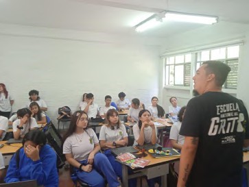
¡Aquí podemos ser! Cartografía de Espacios Seguros en Medellín a través del Mapeo Abierto
En Medellín, estudiantes de 9˚, 10˚ y 11˚ de la Institución Educativa Tricentenario se unieron para identificar y cartografiar los espacios que perciben como seguros y acogedores para expresar su identidad libremente.
Mapeo Humanitario con WhatsApp: Introduciendo ChatMap
ChatMap convierte los chats de WhatsApp en mapas instantáneos, extrayendo datos de ubicación y mensajes. Ideal para áreas propensas a desastres, fortalece a comunidades con habilidades tecnológicas limitadas, incluso sin conexión.
Announcing our #MapGiveImpact Telemapathon Guest Speakers!
Our #MapGiveImpact global, 24-hour telemapathon is just around the corner. We are excited to present our star-studded guest speaker lineup for each of the 2-hour sessions.
