Update on disaster response activations for Morocco and Libya
Posted by Pete Masters • Sept. 20, 2023
Discover how the OSM community and other partners are responding to the devastating events in Morocco and Libya, how you can contribute, and where relief organizations can find data to support their efforts.
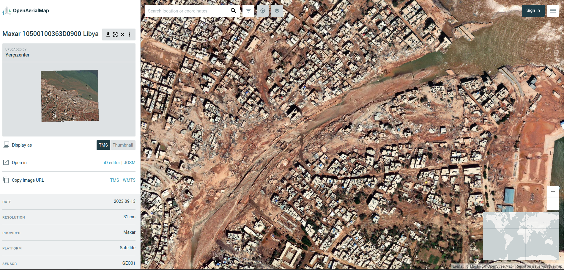
Cover image: A screenshot from OpenAerialMap showing the devastation to the city of Darnah in Libya (imagery courtesy of Maxar)
The devastating events in Morocco (earthquake) and Libya (floods) happened within two days of each other on the 08 & 10 September 2023. Both have meant large-scale destruction of infrastructure and thousands of tragic deaths and injuries.
OSM communities in both countries (OSM Maroc and OSM Libya), alongside partners, have responded, with huge support from mappers from the OSM community across the world.
The latest…
The OSM community response
Approximately 1,600 mappers have so far contributed to both campaigns, creating ~220,000 buildings and ~5,000km of roads.
Validation teams at HOT and UN Mappers have been busy providing quality control and trying to keep up with the rapid pace of the mapping.
More than 1,500 mappers have added data to support responders in Morocco. One project on the HOT Tasking Manager has so far been completed and there are four more available for mapping (as well as a damage assesssment project which is reserved for advanced mappers).
 Contribution statistics for the Morocco earthquake response. Source: ohsomeNow Stats. Heidelberg Institute for Geoinformation Technology at Heidelberg University
A smaller group of mappers, supported by UN Mappers, have swiftly completed the first road mapping project in Libya and are progressing on the first building mapping project.
 Contribution statistics for the Libya earthquake response. Source: ohsomeNow Stats. Heidelberg Institute for Geoinformation Technology at Heidelberg University
In Morocco, experienced mappers are also mapping from high definition, post-disaster imagery to try and identify inaccessible roads and damaged infrastructure, in order that responders can incorporate this data into their logistical processes.
 A blocked road in Morocco identified by a HOT validator on Slack
Data for data users
The map data is available directly from OpenStreetMap as always, but also in curated packages via OCHA’s Humanitarian Data Exchange (HDX). The HDX platform is a repository for all kinds of data, and a quick search for Morocco and Libya will return many data sets from many organizations that might be useful to responders and analysts. See here for Morocco and here for Libya - and HOT refreshes these packages every six hours. The information has also been updated with newly added Arabic names in multiple GIS data formats for download.
Since the events, downloads have spiked for many of these data sets as responders seek information to support their activities (see here for a previous diary post on the significance of this from the Turkey / Syria earthquake)
As always, many of the maps and infographics being produced by humanitarian organizations are based on the data provided by OSM contributors. A quick search on ReliefWeb brings many examples, such as the one below from MapAction (see data sources for OSM attribution).

The team behind OSMAnd has also made maps of Morocco and Libya freely downloadable to support teams in the field.
 OSMAnd make their Morocco and Libya maps available. Source: Twitter/X
OSM used in innovative methods
OSM data is also being incorporated into analysis by Microsoft’s AI for Good Research Lab to try and establish the extent of the damage caused by the flooding in Darnah. You can explore the before and after using this visualizer.
 Before and after the floods in Libya from the Microsoft visualizer
How can you contribute?
-
If you are a mapper, please jump in and map some tasks! Campaigns in the HOT Tasking Manager are here for Morocco and here for Libya. There is still a lot of data needed for the affected areas.
-
If you are a community organizer, you can organize a mapathon to mobilize your community members to support these efforts. If you want support, please reach out on the HOT Slack.
-
If you are a responder/data user, please let us know what you need! You can do this via email, HOT Slack, Twitter, or any other means.
-
If you see OSM data used in the response to either of these disasters, please flag it with me or anyone at HOT. The people who map for these activations do so out of solidarity and humanitarian spirit, and there is nothing more motivating (and I include myself in this) than seeing the data we have contributed supporting responders and having an impact on the ground.
-
If you want to get the latest news, follow the Open Mapping Hub - WNA or HOT on social media.
Thanks to OSM supporters
A big thanks to Maxar, who very quickly activated their Open Data program and released recent imagery for both areas, which is now hosted on OpenAerialMap.
And, also to TomTom and AWS, who have both contributed through the mobilization of resources (mappers and funds) to support these responses in North Africa.
Organised editing documentation:
Following the earthquake, OSM Maroc, supported by HOT’s Open Mapping Hub - West and Northern Africa, launched the 2023 Morocco Earthquake activation, and OSM Libya did likewise, launching the 2023 Libya Floods activation, supported by HOT and UN Mappers.
See original text posted on 18 September 2023 in OpenStreetMap
Share
