News
Kickoff of HOT's Participation with the InAWARE Programme

The Humanitarian OpenStreetMap Team’s (HOT) participation in the InAWARE program kicked-off last week with stakeholder workshops in Jakarta and Surabaya, Indonesia. The Badan Nasional Penanggulangan Bencana (BNPB) graciously hosted the event at their headquarters, which was lead by the Pacific Disaster Centre (PDC) and attended by the Massachusetts Institute of Technology (MIT), Disaster Management Innovation (DMI), HOT and various other stakeholders.
New Features for OpenAerialMap
OpenAerialMap is focused on creating a simple and easy experience for finding and publishing aerial imagery. This past week, we released three new features...

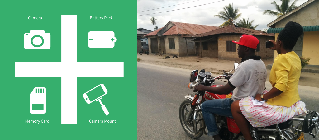
Introducing the Mapillary Humanitarian Mapping Kit, in Partnership with HOT
Guest post by Sandra Uddbäck, team member at Mapillary. Humanitarian OpenStreetMap Team (HOT) does amazing work in building and supporting local mapping communities around...
HOT Launches New PacDID Drone Imagery Project
Earlier this month HOT launched the new Pacific Drone Imagery Dashboard (PacDID) project to support aerial imagery use in Pacific island communities. In places...

The White House Mapathon and HOT Team Up to Fight Malaria
On Thursday, July 7, HOT will join the White House Mapathon to celebrate the role of open mapping in the achievement of the Sustainable...

Using Financial Services data in OSM: GIS Poster and Mobile apps
Geospatial data lies at the basis of large portions of web and mobile applications, but sometimes tends to be undervalued and is often not...

HOT's Commitment to the Sustainable Development Goals, and How You Can Help
When I speak with HOT staff and volunteers in our community, I often ask what they've heard about the Sustainable Development Goals, or SDGs for short. Sometimes, people have heard of the term, or know that the term is somehow related to the United Nations. I often chat about the types of mapping projects they're working on. In the past month, the answers have been incredibly varied: HOT staff are mapping safe bicycle routes and access to sanitation (public toilets) in Tanzania; banks, ATMs, and mobile money agent locations in Uganda, and are about to start mapping critical disaster "lifeline" infrastructure in two of the biggest cities in Indonesia. In addition, HOT volunteer leaders are working on dozens more projects throughout the world across sectors: education, environment, health, transportation, water and sanitation. These projects are all taking place in challenging contexts: megacities in developing countries, refugee camps, and unplanned urban and rural housing settlements.So what does this have to do with the SDGs?

HOT inspires mapping communities in Uganda
The last time that HOT carried out mapping in Northern Uganda was on August 20 2012, teaming up with the American and Ugandan Red...

Mapping Bicycle Routes During Dar es Salaam's Cycle Caravan.
Each year, 5th June marks World Environment Day, a day for raising global awareness to take positive environmental action to protect nature and the...
Call for Proposals - HOT Summit 2016
We invite you to submit a proposal to present a topic of interest at The Second Annual HOT Summit 2016 to be held in Brussels, Thursday, September 22nd at the BTC Conference Center - Espace Jacqmotte the day before State of the Map-International. This year's theme is OpenStreetMap, the Global HOT Community, and Achieving the Sustainable Development Goals.
HOT and YouthMappers Collaborate to Develop HOT University Clubs
The Humanitarian OpenStreetMap Team (HOT) and YouthMappers share a common vision around engaging young people interested in the use of spatial data for humanitarian response and development. YouthMappers and HOT have already collaborated in many ways, including through use of HOT’s Tasking Manager, which is the platform used for collaborating in groups around mapping projects.

Ecuador Earthquake: Assessing the Extent of Damaged Buildings
Efforts are still going strong 7 weeks after the initial earthquake struck Ecuador on the 16th April close to the towns of Muisne and Pedernales, with HOT transitioning from the 1st stage of mapping focused on pre-event data to the 2nd stage, a pilot project aimed at mapping building damage and temporary shelters.

HOTOSM recognized by the President of Mexico during Internet Day 2016
(Welcome and thank you Miriam Gonzalez for this guest post, sharing recognition by the President of Mexico of HOT during Hurricane Patricia! -Mikel) On "Internet Day",...

New project: “Real Time Financial Location Planning and Research”
Humanitarian OpenStreetMap Team (HOT) announces it is a Grand Challenges Explorations winner, an initiative funded by the Bill & Melinda Gates Foundation. HOT will pursue an innovative global health and development research project, titled “Real Time Financial Location Planning and Research”.

New Documentation and Design System for OpenAerialMap
We've just rolled out the start of a new documentation and design system for OpenAerialMap. Four main components make up the OAM ecosystem: an...
HOT at the World Humanitarian Summit
From May 22-25, six HOT board members, staff, and volunteers will participate in the first ever World Humanitarian Summit in Istanbul, Turkey. The World Humanitarian...